As someone who’s grown up within a five-miles radius of certain North Somerset villages, I like to think that I now know my local woodland and walking areas quite well.
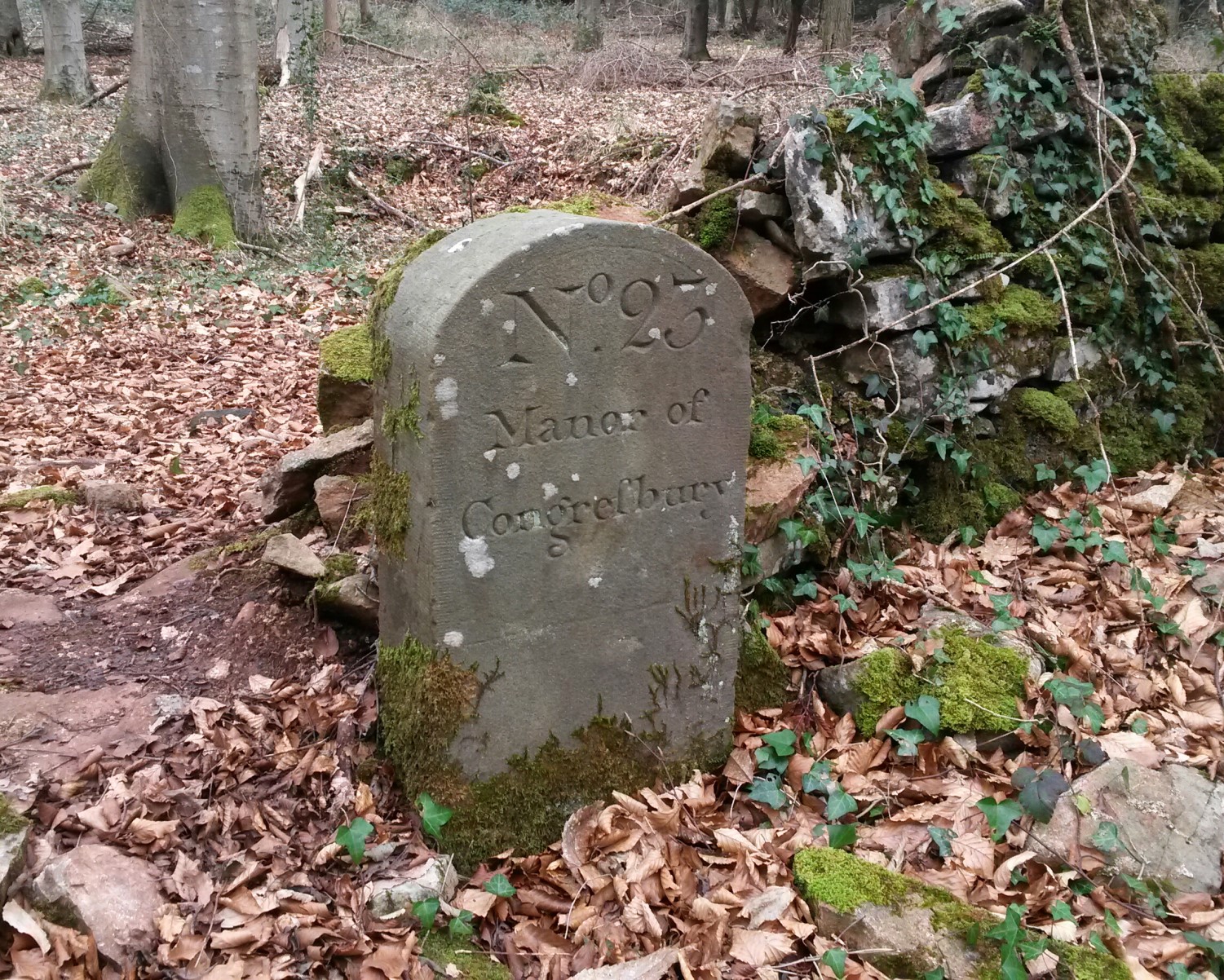 But it was while out walking the woods of the Congresbury Estate last weekend, that I encountered a boundary stone that was unlike many others I had seen around the country.
It reads:
‘No. 23 Manor of Congresbury’
Further reading and a little bit of internet research has led me to learn that there were originally around thirty stones like this, defining the original parish boundary of Congresbury [pronounced “Congsbry”, by us locals] from what was part of Yatton and is now Cleeve. These stones were laid out sometime in the second half of the 18th Century, if I’ve remembered that correctly.
I only came across this one by way of an accidental trespass… With a lack of clear waymarking towards the south of the estate and many paths and tracks to complicate any decision making, I set off alongside a dry-stone wall on a worn path that ‘looked right’… Until I soon realised I was heading further east through Corporation Woods, when I should’ve been descending south past Ball Wood.
Approximate grid reference: ST 462 642
Following the dry-stone wall on your right, it’s very hard to miss on the south side of a gap in the boundary.
As I read elsewhere online; Ordnance Survey have somewhat complicated any intention of rediscovering all remaining stones by listing all boundary stones (BSs and BS) in an identical matter than doesn’t distinguish the engraved stones from the rest.
Thanks to an e-mail from local resident Chris Short, I’ve also learned that great strides have already been made by local archaeologists (thanks to Vince Russett and with the relevant landowners’ permission) to find around twenty-five (again, I’m working off my memory) of these boundary stones and assess their current condition.
Chris also had a small article published in a local paper last year, where he asked for the help of local people and also for information on the act of perambulation… To which he recently informed me that the parish council organises an official perambulation (a beating of the original parish boundary) every few years.
To me, it sounds a bit like the annual thirty-one mile perambulation of Exmoor’s former forest (in 2015, I completed the half-distance challenge).
I can’t imagine the “Congresbury Perambulation” would be as well-attended but I hope that the next event reaches a reasonable level of awareness so that more people can be involved (yes, I’m raising my hand, here).
Have you seen similar boundary stones in your local area?
Do you know of any other regular perambulations taking place in the UK?
Today as well, I was out walking on the Mendip Hills near Axbridge when I encountered the follow inscribed stone (‘Ax’), north of Fry’s Hill:
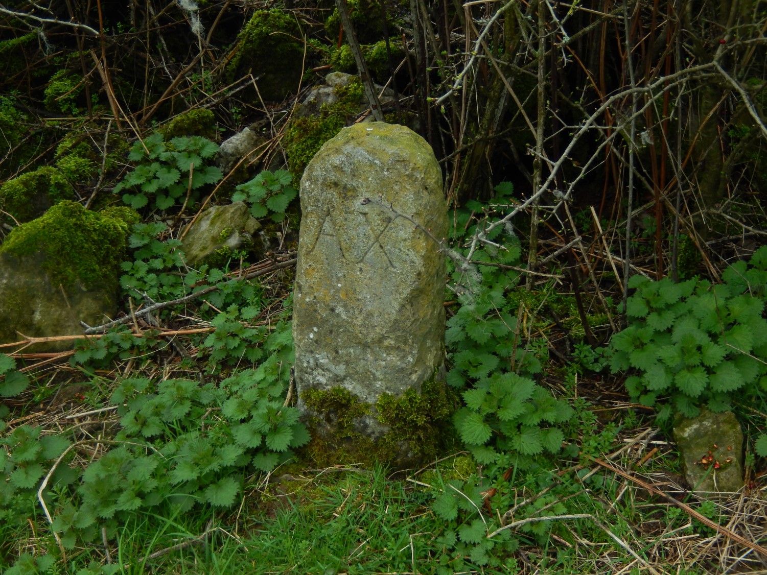
An approximate grid reference for this is: ST 438 561
It’s along the northern side of Callow Drove, just before the T-junction of paths at Callow Hill. I’m sure I had noticed this one before but didn’t think much of it before passing by today, having found the one in Congresbury last weekend.
I’ll include a few links for further reading on the Congresbury stones below. Perhaps next time I’m out getting lost in those woods, I’ll uncover another!

Hi finding one of these stones in the grounds of one of bristol waters reservoirs i started to research what it was and found myself here 🙂 if you walk up the track oposite the star on the rhoddy pub to the waterworks gate a few hundred yards up pear over the gate to your left you will see the stone the inscription is on the other side from where you will be looking at it and hasnt weathered well only parts of it still readable number ending in a 2 and only the end bit of congesbury. The reservoir appears to be build over the boundary line.
LikeLike
Hi Daniel,
Given your use of the term “Rhoddy”, am I right to assume you’re a local?
I moved away from Wrington six years ago now and never got around to discovering many more of the stones than what I detailed in this post.
LikeLike