
Good Friday 19th April 2019
A four-day Easter break had begun. No need to be up early or endure slow-moving traffic in a journey to the mundane. It was forecast to be a bright and beautiful day. I wanted to spend it outside but I didn’t want to have to travel far.
Having moved to Weston-super-Mare only a few weeks earlier, I’d decided that this would be my first proper walk from my new doorstep. Leaving the car alone, I would walk in the direction of Sand Point.
I won’t go in to the reasons as to why I’ve left the Mendip Hills behind for this slightly-less-rural way of life… But I had been looking to move for some time and, from a financial point of view, I had a budget and the bulk of properties that I could afford seemed to remain in this area.
I now live right on the very edge of the town. Close to countryside but not comparable to the hills and woodland that I had on my doorstep in Wrington. I’m safe enough from the busiest urban areas yet only a short walk from the nearest supermarkets and conveniences.

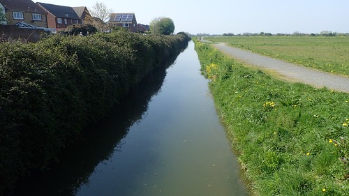
I’d been eyeing up a right of way that follows the River Banwell and would use this as my starting point. I’d never heard of this particular river before moving here and didn’t anticipate finding much… So, it was a pleasant surprise to find something a bit more than your typical lowland rhyne.

Footpaths in this area are relatively well surfaced and maintained. Frequently used by dog walkers. Parts of my parish are barely two decades old, if even that. There were even cattle grazing, metres away from the paths!

I was also impressed with the quality and frequency of signage and waymarking along these routes. I grazed the edge of this parish with Anna in 2015, when we began our (still unfinished) walk from Bristol to Lynmouth along the coastal paths.

Passing through Ebdon, I met with some familiarity from that previous journey.


As on that coastal walk, I followed the eerily-quiet bridleway up through Ebdon Farm. I try to avoid walking through farmyards where possible… But there was no great incident to report of, on this occasion.

Away to the south-west, I could see Weston Woods and Worlebury Hill. If you know Weston-super-Mare at all, you’ll probably have noticed its a pretty flat place, hence why this former hillfort stands out.

After a good mile or so, I’d leave Kingsfield Farm to join Collum Lane, heading north. Had I seen a ‘Bull in Field’ notice at the other end, I might’ve entered this great expanse of green with more trepidation. Not that I saw a single calf or bull.

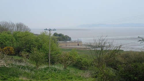
From the road now, I could see Sand Point and Middle Hope. Not even fifty-metres above sea level at any of the high points.

My plan had been to follow this road towards Woodspring Priory but to turn right before then and follow a track through a National Trust car park to head up on to Middle Hope…

Having seen ‘Car Park Closed’ signs, I was concerned that I may have to turn back and fight for an alternative route… But a footpath diversion had been set in place, even if the cars couldn’t stop here.

Apparently this work has been ongoing since 2018, although I was fortunate to pass through shortly before it started. What the Environment Agency are doing is to is to upgrade one of the outfalls leading to the estuary. I’d hope the work was a sign of progress on the proposed walking and cycling route to link Clevedon with this area – but, we’ll have to wait a bit longer for that.

I passed one friendly dog walker on the way up to a point at which I would reach these views, looking north-east towards Clevedon over distinctly private land, forever lacking in a coastal route for public access.
Current proposals to boost public access including utilising the sluice crossing at Tutshill Ear, between Wick St. Lawrence and Kingston Seymour. Fingers crossed!
There was once a pier reaching east from St. Thomas’ Head. At some point in recent years, it has unfortunately been removed and for some reason I’m unaware of.

Security fencing around the site has also been reinforced, if not replaced. For the last few years, grazing sheep and ‘urban explorers’ have been able to cross the boundary with ease. All of the buildings have been removed.

Now walking west along the peninsular, the views of the way ahead begin to broaden. Illuminated by the flourishing colours of spring.

Looking south across Kewstoke, I can see the populated and built-upon northern slopes of Worlebury Hill.


From my front door, it had taken me around ninety-minutes to walk as far as the Middle Hope car park (which isn’t stated on the OS maps). From there, I probably spent another half an hour (if not more) walking west towards Sand Point.

It’s interesting to see the fresh-looking ladder stile in this photo because, prior to writing this post, I spent a weekend in mid-to-north Wales. On a walk around the Berwyn mountains (outside of Snowdonia National Park), we encountered a succession of such stiles, missing individual treads and sometimes more.

This was Easter. Windy but with the sun shining. An inviting day for may to get outdoors and I was struggling to find the desired solitude within my own mind. A peaceful place to sit and take in my lunch.

I managed to tuck myself in to a nook or crevice leading down to the rocky bay. Sheltered from the wind. Secluded from the passing eyes above me. I spent a good half an hour just sitting here after finishing my food.


I wouldn’t venture quite as far as the western tip of Sand Point; preferring instead to leave other visitors to appreciate the space alone. I would now begin a steady descent through the National Trust car park and on to Sand Bay.

But for all the mud out to sea, Sand Bay does not disappoint with its name. Forever, a popular place to walk your dog or take the kids. It was always going to be busy, here. If not nearly as packed as those looking to explore the Grand Pier, further south.

Dilapidated Birnbeck Pier stands away from the western end of Worlebury Hill.

I would normally follow this boardwalk from the beach to the next car park – not owned by the National Trust but it is now pay-and-display, where it was previously free to park here. I mindlessly hopped over the wooden barrier at each end to walk along… And soon discover why the barriers were in place, as several boards are in need of replacing, without looking at the supporting structure beneath.
Perhaps a pair of warning signs could’ve also been useful? I hope that repair work is in the pipeline for this, even though North Somerset Council is currently in a state of ‘limbo’ following recent elections.

I crossed the road and found bluebells on my way up through Weston Woods. At just over 100m above sea level on its highest point, this required some exertion from the coastal road.

Another busy spot with people walking slowly at every turn. I marched on. East along the top of the hill until I was on the roads.
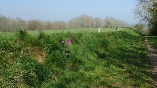
I followed the sunken bridleway beside Worlebury Golf Course, keeping my eyes peeled to the left for potential incoming golf balls.

Standing over a quarry at the height of my inevitable descent, I could see little but for the sea of houses ahead of me… Worle. Not a patch of green land visible and I would have to navigate my way through it to get home.
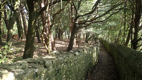
Actually, I was impressed to find this twin-walled path snaking down around the quarries and to the next road. How old was this right of wall? I thought of the medieval walls in a town like Axbridge.

Some sections of my return route were like this. Away from the noisy cars. An undeniable way to follow, with the additional support of GPS navigation on my phone.

One successive footpath led me briefly across a field, where I discovered this former tent, trampoline or something-else left to rest in the hedge.

Otherwise, this patch of land was a very pleasant discovery, as I made my way deeper in to and across Worle.

Worle is regarded as being a large village and the internet also suggests that it may’ve surpassed and outgrown its governing town of Weston-super-Mare.

It was inevitable that I would soon discover someone else’s rubbish left along one of these narrow pathways. Just a couple more miles of concrete and solid ground to go.

I passed the millennium stone as I crossed the green grass of Castle Batch and, from North Worle, I was heading towards the northern extremity of St. Georges. There was once a railway line passing close through here that would link Clevedon and Portishead with the area.
I find it interesting now, to think of how inaccessible those ‘neighbouring’ towns are to anyone who doesn’t drive or cannot hitch a lift. In the same ways that plans to re-open to long-disused railway link between Bristol and Portishead and still being discussed.
…Would it not have been cheaper to have left the tracks in place?! For the sake of a rainy day.
It wasn’t long from here before I was home, having rejoined the River Banwell for the final stretch.
I don’t know how often I might repeat this route but it was refreshing to discover that a greater range of countryside exists on my doorstep than what I’d anticipated. Walking to Sand Point from home will always be an option. Illegal wild camping? Who knows! 😉 I’ll try to share more of what I find locally over time,

Hi Olly, nice write-up👍
I wonder, as a local, do you know if it is possible to cross the River Banwell at Collum Farm, i.e. here? Aerial views show some sort of bridge there. It’d save a big detour down to Ebdon on my round-Britain coastal walk if it is possible!
Thanks
Paul
LikeLike
Hi Paul,
Thanks for reading, subscribing and for your comment!
I know the location you’re referring to. There are signs on the gate there to say it’s private land. No public right of way exists along there, sadly.
To the east of the river, there’s a clay pigeon shooting range.
It’s a great shame that access hasn’t been opened up or created here. They did come up with the Pier to Pier cycle path (as you’re probably aware) but it’s too far inland to be truly coastal. Before that, bloggers have been know to trespass their way to/from Clevedon… But of course, you’d do so at your own risk.
I hope that helps.
Olly
LikeLike