
Saturday 30th March 2019
This would be my first Black Mountains walk of the year, having previous done a shorter route in a similar area with my friend Dave, back in December.
Everything was planned for a great sixteen-miles in these brilliant mountains. My bag was packed. Lunch prepared. As I bent down to put my shoes on and, before I could even tie my laces, something ‘went’ in my lower back.
I was on the floor for a good five minutes; unable to pick myself up without experiencing immeasurable pain, just above my left hip. I have a weakness in my back higher up; the kind of pain that jolts and then ‘pops’ back in to place… This was everlasting and had threatened to ruin my weekend. A forecast dry and sunny day that I did not want to miss. Then, the following day would be my birthday.

Slow and unsteadily, I made my way downstairs (shoes on) from my new flat and awkwardly in to my car. Was I really going to drive all the way to South Wales and endure this hike?! I didn’t want to waste my weekend in Weston-super-Mare.
With much grunting and swearing along the way, I made it to the Blaen-y-Cwm car park in the Mynydd Du Forest. Boots on, Ibuprofen down my throat. I realised I could still walk. At the very least, I would head up towards one ridge and come back down.
Zig-zagging my way up through the forest, as I had done with Dave in December, I climbed a stile to break out on to open land beneath Bwlch Bach.

My challenge now was to climb up on to Chwarel y Fan; a ridge that either translates in to ‘quarry of the place’ or… ‘Place of the quarry’, according to my limited knowledge of the Welsh language; occasionally interjected by Google.
If you look on an Ordnanace Survey map, the only visible path from SO 255 288 follows the lower boundary south and around Bal Mawr (Dave and I followed most of this, previously). On the ground, I could see that my plan to ‘handrail’ the boundary in a north-eastward direction would lead me straight up to the site of the disused quarry.

It wasn’t easy. Neither was it the hardest climb I’ve done in this part of the world. As always, it was worth it for the somewhat-hazy views.

Looking west across the valley, I could see the distinguished, raised plateau of what I’d always assumed was Waun Fach, the highest point in the Black Mountains… In fact, a number of Google Images will also suggest the same. But I now suspect this is Pen y Gadair Fawr and I hope that will make more sense as we continue on.
(I’m also willing to be shown that I’m wrong!)

I followed this ridge south, along Bwlch Isaf (lowest pass) to Bal Mawr, where I had intended to stop, photograph and admire the stonework trig point… But a Mountain Rescue team had pitched a tent right next to it. They were stationed for some kind of walking event… It was too soon in the year for the BBMC. Someone has suggested it might’ve been a Welsh Three Peaks challenge.

Descending from Bal Mawr and in to the next mountain pass, I did cross two groups of people heading in the opposite direction. They were clearly taking part in an event. Most were friendly enough to say hello.

As I couldn’t stop beside the trig, I decided I would stop at Bal Bach before my descent. Down to my left, a group of younger people were climbing up from the direction of Llanthony, along with further groups of participants to this mystery event.

One group were on some kind of navigation course or training, similar to what I did in November 2017. They counted their double-steps along one-hundred metres to get a sense of their pacing. Then, their instructor was helping them to recognise features in the landscape, before indicating a point on the map for the next member of the group to take a turn in leading and navigating towards.

I allowed them a head start, as I realised we were headed in the same direction. Once I’d finished my tea, I began my own descent, to realise they were in fact taking a different route.
Keeping my head up and eyes open (just as I was taught), I used the treeline as a visual aid in navigation, since there is no discernible path, on map or ground, between here and my next marker.

I then followed the edge of this forest to find my exit from the open hillside. I’d once been told that Bal Mawr is a ‘very boggy’ area… But this was my second walk in the area (following one in the midst of winter) and I didn’t finding any threatening patches of peat. Neither did I see or here another soul. Just the sounds of running water.

I took the track from SO 262 262, turning left to head down through the dense, dark woodland. A very cool and refreshing place to be, on a day where the temperatures reached double-figures and a breeze could not be felt.
…In contrast to the mountain weather forecast I’d seen the previous evening; which had offered a sub-zero “feels like” temperature. In preparation, I had my merino thermals on and I was suffering! With or without the back pain.

I dropped on to a dry, stony forestry track, knowing that I’d come the right way.

I cannot explain why a needle had been forced in to this fingerpost… Here, of all places! Halfway about a valley in rural South Wales!

According to my map, I could cross this track and follow a byway down in the same direction… But there was no evidence of any way through. I spent a good half an hour walking up and down the main track; searching for other avenues. I even followed the stream halfway down, only to have to retreat at a dead-end and burn more energy in my vertical escape.

Had I pre-loaded the map data on to my phone (there was no service in this valley), I’m confident the GPS signal would’ve shown I was in the right spot. Reluctantly, I was resigned to following the broad and boring tracks in a great but gentle meander towards the bottom.

I believe I reached the road at SO 255 265, while I believed that I was a few hundred metres further south… And spent ten minutes walking in the wrong direction! I’d driven along this road earlier to reach the car park and was quickly able to recognise enough in the landscape around me to correct my mistake.
As for the Pot Noddle and beer can, I have no idea who, why or when. I don’t like either!

It was hard to miss the left turn I was searching for, thanks in part to this green grit bin.
More forestry tracks. Dry and boring. But ultimately devoid of noisy people.

Still without GPS, I was able to negotiate these tracks by recognising the landscape feature of Cwm Ddeunant. From there, I could follow finger posts from the mountain bike trail and along a footpath through the woods, with untarnished dirt beneath my feet.
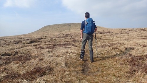
Back in the shade, I continued to climb. Slow, steady and tiring. It was very close to my intended lunch top. Somewhere beyond it, perhaps. I was determined to get to the top of this climb.

‘Gadair Ridge’. Chair or fortress ridge. I always find it interested when the Welsh substitute a G for a C, or an F in place of an M.

Following the right of way across one of two tracks, I met a gate that had been unhelpfully tied shut. Scrimping on the cost of two hinges was bad enough. There was no way to open or safely climb this one.

…So, I took a minute to reconfigure the knots so that a loop could now be fastened over the top of the gate. Holding it in place while also allowing for easier access. I assume someone’s just trying to keep their livestock in place.

Free from the woods, I rose out on to an unnamed summit, marked by a small cairn. A small reward for a great amount of effort.
Ahead of me now, I could see the outline of Pen Allt-Mawr (right), Pen Cerrig-Calch (middle) and Table Mountain (barely visible to the left).

If you’ve not been up on the Black Mountains before, you can expect a lot of peat, heather, gorse and your typical moorland scene. Elevated, as I imagine Kinder Scout will be, when I explore that area in July. Less desolate and isolating than Dartmoor.

Continuing north along this higher ground, I met another cairn at Pen Twyn Mawr… Which I think translates in to ‘big dune top’… I could be wrong. That sensible voice inside my head suggested that I should stop for lunch here. But I wasn’t comfortable with the neighbouring bugs and no breeze to blow them away. So, with the sense of fatigue growing, I plodded on.

Far to the south and behind me, I could just make our Sugar Loaf, through the haze.

From reaching the Gadair Ridge, I’d first assumed that this raised plateau was again the ‘small moor’ of Waun Fach… It seemed to be the right kind of distance. Not too far and reachable before a late lunch.
…When I did come to check my phone and the GPS signal, I could see that it was ‘only’ Pen y Gadair Fawr. My original plan had been to stop for lunch there but, by this time, I’m sure it was somewhere past 14:00.
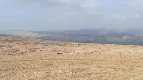
North-east of here, you can identify three ridges. First, is the Chwarel y Fan ridge I followed earlier. Behind that is Darren Lwyd (the short one) and then Offa’s Dyke. It’s possible that the Black Hill, Crib y Garth, can also be glimpsed.

Pen y Gadair Fawr (top of the big chair) stands at 800m above sea level. North from here, a very obvious path leads way to Waun Fach (small moor), at 810m above sea level. Before anyone of that, I was going to stop for lunch on the edge of the big chair.

This wasn’t a place or time for solitude, though. As I arrived at the summit cairn, a family had already ‘claimed’ it and showed no signs of moving on. When they did leave, a group of others had already made their way to the top and, as their time came to pass, another crowd was waiting!

I did enjoy at least thirty-minutes for lunch, though. I needed that. By the end of it, much of the sky had clouded over and the cooler temperature allowed me to progress on more comfortably in my thermal layering system.

I followed the obvious path to the top of Waun Fach in the trail of several mountain bikers. There really isn’t much to show of the “summit” itself… Geographically, it is correct. But it lacks the distinction of many, many, many other high points around the world.
Had a group of Duke of Edinburgh kids not arrived in the same moment, I’d have photographed the ‘OS’ stone that probably depicts the location of the trig point that allegedly sank in to peat a few years ago. When I first walked here a few years ago, I carelessly walked on past the summit unaware that this was it!

Losing a small amount of elevation, I followed the ridgeline north and passing this cairn, which possibly marks Pen Manllwyn. I’d fuelled myself with water-soluble energy tablets and a mint-chew caffeine bullet to get this far after my belated lunch stop. Now, all I wanted was to reach that familiar descent in to the valley down to my right.

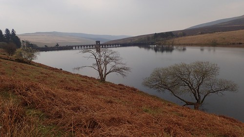
A path I’d walked before; this would lead me down past Grwyne Fawr Reservoir and on to the car. It’s quite a long-winded way to go and appears to be the only option marked on the map. I’, planning to lead a group here in June and have wondered about making an off-piste detour from Waun Fach direct to the southern end of the dam that bridges the reservoir.

On the way down, I was disappointed to spot this banana skin. In fairness, it was the first I’d noticed for several months. Perhaps people are learning that they take many, many years to decompose? Can you spot anything else that’s yellow in the photo above?…

Wild campers. In their BRIGHT YELLOW tent. What you can’t see is the guy wearing a BRIGHT YELLOW shirt. Wild camping is not legal in any part of Wales – although, yes, you can ‘get away with it’ by exercising caution. I’ve yet to brave my first wild camp – and I can almost promise you it won’t be “legal” – but I strongly believe there should be an element of stealth involved. Bright colours and clear visibility from the footpath… I don’t think they gave it much thought.

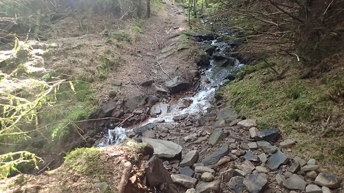
Continuing down the valley, this trickle of water grows in to a river that fills a man-made reservoir.

It’s increasingly well known that there’s a bothy above Grwyne Fawr Reservoir. I wonder how secret this was, say, five years ago? People’s interest in walking and the outdoors seems to have exploded in recent years. Two more campers (albeit, in a darker tent) had pitched up beside the bothy.
With such a spectacle on offer, you can see why people would be keen to pitch up close by. A caught glimpses of sounds of other wild campers not-invisible beneath me. With the temperature already cooling at around 17:00, I put an extra long-sleeved layer on, wary of the waking midges.
I felt a bit sorry for these brave campers, pitching next to a large to a source these blood-feasting nasties probably call home.

This was my third visit to the dam at Grwyne Fawr and I’m sure this was my first time walking across it. I only made it about three-quarters of the way along, as I spied yet more wild campers at the other end! One guy had cycled back across the dam to collect firewood from a fallen branch. Camping is one thing but wild fires in the outdoors… They’re not even legal on Dartmoor.
Had I been carrying a larger hydration bladder, I might’ve attempted to douse their evening.


I’d soon return to my car, grateful to have endured such a challenging walk with my back still in a mess. A day not wasted that could easily have been spent in bed. I also had my own thoughts about wild camping in this area, how and where to source water and where (not) to pitch.

