
Thursday 30th May 2019
Somehow, I’d survived the night. With my shoes and waterproofs still damp from the previous afternoon, the morning of my final day had arrived. After an almost-sleepless night, in which I didn’t boil any water to prepare a meal. I endured. I’d survived. I’d made it this far and I was now around ten-miles away from Eastbourne, with the prospect of a stunning coastal walk to follow.
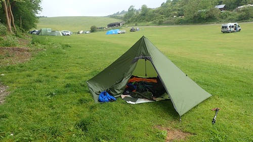
I was up and out of the tent by 7am. Here, you can see my pitch… Awkwardly upon a slope and anything but comfortable or well laid-out. I’d thought that the trees overhead might offer some protection from the rain. I was also aware that leaves and branches equate to large and loud water droplets… I’m sure you can guess which was most likely!
Fortunately, I still had one dry set of clothes, save for my only pair zip-off trousers, which were still damp. I’d worn the previous T-shirt and underwear for an extra day over the two I’d packed for, meaning I could begin this walk in some comfort. Even without dry footwear.

Before leaving, I briefly reacquainted with the two backpackers I’d almost been tailing since Day Two. I thought I’d spotted their tent the night before (on a sensible, flat pitch) and it was good to see them one final time. They talked of not finishing the trail, due to the arrival of fog that was due to stay in place all morning and how they’d rather save the opportunity for a clear and brighter day… I was surprised, especially as they had a B&B booked in Eastbourne. I hoped they would at least walk the inland bridleway route past Jevington. This was at 7am… They were ready to begin their day while I’d yet to make breakfast. We said our goodbyes, wishing each other well and still without exchanging names.
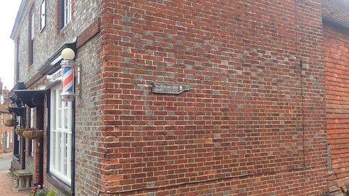
Another hour would pass before I was packed up and ready to return to Alfriston. I would happily recommend the campsite. I was only disappointed with the weather… Which was hardly the owner’s fault! Rediscovering the trail from Alfriston was easy and I ironically passed a barber’s shop, having considered getting my hair cut in preparation for this long-distance walk… My hair remains untamed to this day!

It’s when you arrive at this bridge crossing the River Cuckmere that a decision must be made on your way forward.
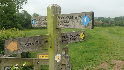
Cyclists and horse-riders have no option but to follow the bridleway north and on towards Jevington, passing The Long Man chalk sculpture in the hillside. Walkers, however, are welcome to a distraction-free riverside route, leading on towards the south coast.

For me, there was no other option. I hadn’t explored the coast anywhere east of Dorset and the prospect of walking beside the sea was one that I was keen to follow. This also meant that there was GRASS beneath my feet. No more path-sharing with cyclists. An end to the punishing chalk downs.

I was, however, sharing this riverbank with a herd of persistent cattle. Unwilling to step aside. I spotted the bull amongst the herd and made an audible comment that I hadn’t expected anyone else to hear.

Following a lower route, I undercut the cattle and made it through without incident. As I reached the kissing gate, a couple with their dog emerged, making reference to how I’d ‘survived, after all’… They must’ve heard me. I watched on to ensure their own safe passage with “bait” on its lead. But these cows weren’t overly curious. It is such a nice path that locals must walk along here frequently.

South of Litlington, my route would undulate along what felt very much like your typical countryside ramble. Quiet roads, field paths and farmland. I’d seen very little of this over the past five days. Such a welcome way to end this trail. I wonder how many others follow such a divergence towards their terminus?

Looking inland across the Cuckmere Valley, there wasn’t an awful lot to look out for. I lost hope in being able to spot The Long Man from a distance. Perhaps once day, I’ll return for the day to walk that alternative stretch of the South Downs Way. But I quite like walking in eerie conditions. Visibility wasn’t too greatly reduced and I felt sorry for my fellow backpackers who would probably be missing this atmospheric finale.

Looking west across the river, I could see the Litlington White Horse chalk sculpture, to the north-east of Seaford. Not something I’d expected to find, so very far from Wiltshire.

I met what might be an original marker stone for the South Downs Way, in the woods of West Dean.

Heading down in to the woods meant I’d have to climb steeply up from the other side. These steps were both large and unwelcome. I wonder whether these are the names of volunteers who reinforced each tread or, were they just youngsters spending a day in the area.

Crossing the A259 from Exceat, I had my first clear view of the south coast, with the Cuckmere River meandering towards it.

If you’re in need of water by this point, there is said to be a water tap available near the toilets of the visitor centre, here. Slightly further back, they may even be a tap near one of the car parks. But I didn’t bother with either. I was very keen to push on and discover.

There are a minor myriad of paths to select from.

Most seemed to favour the low-lying route, close to the river.

Although the South Downs Way does descend to join this momentarily, I soon found myself climbing up and across the Seven Sisters Country Park.
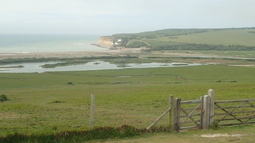
Here’s a view of Seaford Head and Cuckmere Haven, where many appeared to be headed on this day. I stopped on a bench nearby for a discreet change of clothes… I’d set off from the campsite wearing my waterproof over-trousers as regular trousers… But this was proving to be too warm for my liking. So, I carefully made the transition in to damp shorts (lower legs zipped off) and didn’t look back.

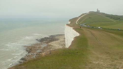
From the top of this climb at Cliff End, I could look back across the bay and Cuckmere Haven. Visibility was… Less than some may desire. But again, I like the sense of atmosphere that this creates.
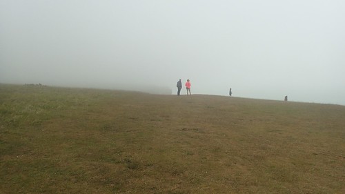
A few people were present, suddenly. Emerging from the mist.
My way forward was obvious, yet unclear.
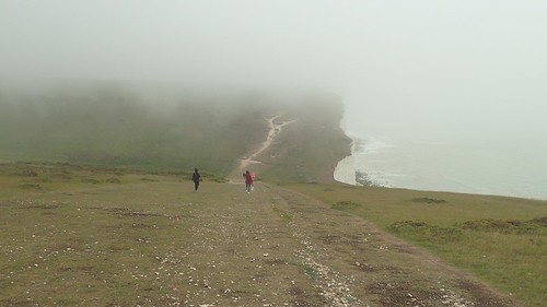
I believe the Seven Sisters refers to a line of Seven cliffs along the coastline. I began counting them as I made progress heading east but then lost count and the fourth or fifth ‘sister’. Keeping track was not important.

Looking back from Brass Point and my own footsteps were beginning to fade.

I remember this day as being windy. But not as chilling or uncomfortable as the previous afternoon. It was dry but not uncomfortably warm.
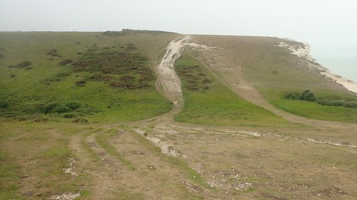
You can see the effects of erosion on what must’ve been the original path and one that may’ve been created to the right. I’ve seen other examples of this on the mountains of the Brecon Beacons. I know that work is being done to preserve and maintain well-worn routes in the Lake District. How long until we see a similar initiative spread across other parts of the UK?


I would pause and wait patiently for the seated visitors to move on, before discovering this Sarsen Stone for myself. Like the chalk horse I’d noticed earlier, this was something I would’ve expected to see much closer to Wiltshire.

I also attempted a selfie, as someone else made emerged from the top of the ascent and fell in to my line of sight. You can see that, once again, I had my damp outer tent strapped to the top of my rucksack.

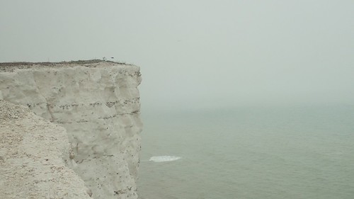
This is my favourite photo from the day and it’s been the desktop background on my computer ever since.


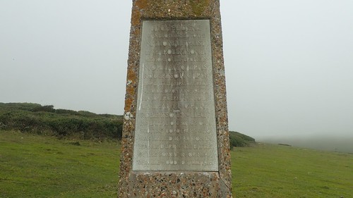
I believe this is the Robertson War Memorial.
I could’ve spent a very long time at any section along this stretch of coast. Strictly speaking, I was in no rush to get home and with no obligation to be back in work the next day. So many opportunities for photographs and, at the same time, I didn’t want to be stepping on to that first train and changing trains around rush hour.


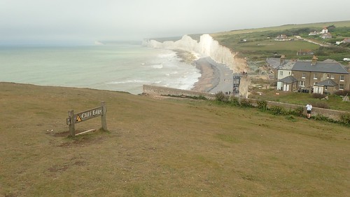
This was Birling Gap. An overflowing National Trust-owned car park, visitor centre, café and obligatory ice cream van. There is said to be a water tap available near the toilets but I didn’t spot it on my way through.


For my liking, it was far too busy with people. Although I did stop to take this photos from the pier-like viewing platform. It was a Thursday but this was still Whitsun Week in the UK, which might’ve explained why so many were not in work at the time.
Another steep climb led me towards the top of Belle Tout.

A large gathering of Japanese visitors – perhaps equal to the population of a large village – had made it to this point. Continuing on, I would pass two “European” tour groups heading west along the trail.

Looking inland again, there was barely as much to see as there was… Out to… Sea.

I do wonder how much of France’s north-west coast might have been visible from here, on a clear day.

This is the lighthouse at the top of Belle Tout. Now a private residence. I also read that it was moved several decades ago, brick by brick, in order to save the structure from imminent cliff erosion. Such an act will need to be repeated in the not-too-distant future.

At some point in recent years, a truly coastal route has been closed and redirected, due to the ever-crumbling chalk cliffs.

I spied a vacant bench on the way down to a small car park (again, pay and display) and claimed it as my own in time for an early lunch.

While I rested, I thought I saw two familiar-looking backpackers overtake me… But it didn’t make any sense. They’d left the campsite almost two-hours ahead of my own departure. They’d told me they weren’t in favour of following the coastal route through the mist. It’s as if I was trying to make things fit in the hope of seeing them again. I even thought we’d made visual contact but there was no attempt of communication.
I’d seen only two other backpackers along the south coast and they were less familiar to me.
Having crossed Birling Gap, I knew that I might have three-to-four miles at best before reaching Eastbourne. Another hour’s walking and I could have finished my first continuous long-distance trail… I was craving the home comforts of a dry and restful place to sleep but I did not want this trail to end.


This might’ve been a memorial to a pre-exisitng lighthouse at Beachy Head.

In the mean time, it was a welcome wind shelter for some. I didn’t stray too close, preferring instead to allow people (and myself) their space.

Across from the Beachy Head pub, I bagged my only pub of the day, having potentially missed one at the beginning of the Seven Sisters. Had visibility been significantly better, I might’ve ventured off to try and find it.

As the South Downs Way began to draw in and away from the cliffs, I knew that the curtain was soon to close on my latest adventure. Possibly the greatest I have accomplished to date.

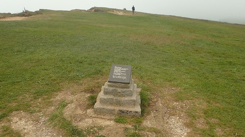
Another memorial can be found ahead of a final descent to rejoin civilisation.

Dropping down from the cloud and Eastbourne become clear. To my eyes, it was more of a small city that the typical seaside towns I’m familiar with.

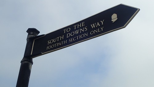
A moment or two later and I had reached the eastern end point of the South Downs Way. One-hundred miles and six-days on from Winchester. There’s even a sign to accompany this information board. A great achievement, less than a year after leaving The Ridgeway after my first day. I’d conquered this one and I felt keen to take on another trail (after a sufficient period of rest, of course).

Who would I meet at the bottom of these steps but the same two walkers I’d said goodbye to at the campsite!! I had indeed spied them overtaking me on my lunch break. They kindly took two photos of me beside the trail (albeit packless, for a moment) and we talked some more about trails we’ve walked and those we might do in the future.
They were intrigued to hear about The Ridgeway and may consider it for their own 2020 adventure. But with two pairs of feet fairing slightly better than my own, they also spoke of an ambition to avoid never-ending chalk downs on their next outing! I share this mindset.

I made an effort to pack any ‘external’ items (including my damp tent) in to my rucksack and retrieved my wallet. A small café with outdoor seating sits beside this eastern terminus. I ordered a ham and cheese panini, helped myself to an oversized chocolate muffin (which I struggled to finish) and also ordered my first decent cup of tea in almost a week!
Two other backpackers arrived as my tea began to cool, although were less chatty than my counterparts. Where must seaside downs have pigeons, I had jackdaws for company, asking for any spare crumbs in a quiet yet uncomfortably close manner!
It was almost time to board that train and begin my long and uncertain journey home. I decided to ignore the map’s ‘most direct route to the train station’ and instead followed the B-road to a country park where public toilets were available (and free to use).

After which, I would head across town to the train station, passing a couple of churches on my pavemented way. Eastbourne Station was surprisingly spacious… Although it’s less of a surprise when you consider the size of the town. I was able to avoid talking to people and purchase my ticket from a machine for almost £50. Having planned the route and platform numbers in advance, I knew where I needed to be and made it on to a carriage with plenty of seats for everyone and room to spare.

From memory, it was a ninety-minute journey to Clapham Junction, where I would need to change trains to a route bound for Southampton. Passing several stops along the way, this train was beginning to fill up, Two businessmen sat opposite me until departing for the airport. Thankfully, no-one made an effort to force conversation with music in my ears.
I knew where I needed to be and I think it was platform thirteen. It took me a few minutes to find, as Clapham Junction seems to have as many levels and staircases as an MC Escher drawing. As I arrived, I read the words ‘CANCELLED’ on the screen… But people still seemed to be heading down these stairs, while others stood perplexed and so, I followed the herd.
Stewards and assistants were almost physically cramming people on to the train. I stood back from their cries of ‘LET’S GO!’. Whistles blowing. No spare seats visible through the windows. As a less-experienced train-traveller, I felt out of my depth and decided I would wait for the next train… Which wouldn’t arrive for more than another hour!
I went inside to the station café to order a decaf tea. It said decaf tea on the overhead menu. ‘We don’t have decaf tea’, I was told… So I settled for a normal tea, despite the fact that I try to refrain from in-taking caffeine where possible. I read my book for a good while before rejoining the queues outside for the next train. Or trains, as I would soon find out.
‘The first train is stopping at Woking’, they said. I wanted the next, which arrived moments later. This meant standing in that ‘void’ between carriages where you apparently can’t hear the speaker. To our surprise, this train also stopped at Woking! I think it was around 19:30 by the time I did arrive at my intended station and I was very grateful that John was able to pick me up and return me to my car, where I’d been prepared to pay for a taxi, chance a bus or even walk for half an hour.
 I treated myself to a Burger King meal at the M4 services before completing the two-hour drive home. At a cost of £11 and my first from this restaurant for over a decade… But it was hot and worthwhile. Since then, I’ve had a McDonalds meal closer to home (and at half the price) but it was barely warm and dissatisfying.
My pack was 4kg lighter (water and food) as I returned to my kitchen. I’d also shed around 4lbs in weight, taking in to account my fast food feast.
My biggest disappointment from this whole experience was in my general lack of sleep. In part, I believe to improper preparation for the lower-than-expected nighttime temperatures. My pack was heavier than expected when I left home… Had I wanted to make a big difference, I could’ve made frequent stops to buy snacks along the way and the odd evening meal in a pub.
That experience of walking for one day, pitching up for the night and knowing I had another day of walking to follow… It’s a fantastic feeling. Life away from the normal. Freedom, exploration and adventure with every step. I have several ideas on where I might walk next. It’s more a question of ‘when’, right now.
If you have any interest in walking the South Downs Way, I would strongly encourage you to do it. Stunning scenery with unexpected undulations. Every day’s a little bit different but do take precautions with your feet.

Congratulations on finishing. The last day over the seven sisters cliffs is the highlight of the whole trail for me. Shame it was misty for you. Birling gap always seem busy there. The row of cottages there’s used to be longer but some have been lost to erosion over the years.
Glad you got through the night ok. Reminds me of one night camping on the North coast of Scotland where it was stormy and the wind flapping and bending the tent all night. Don’t think I got any sleep that night, though I rarely sleep especially well when camping anyway.
So, where next?
LikeLike
Thank you, Jon. It was a definite highlight for me also. I may return one day to experience that coast beneath a blue sky and sun… But I did enjoy the atmosphere surrounding the cliffs and wasn’t at all disappointed by the presence of mist. I never sleep well when camping, either and the same could be said of my sleep at home.
Well, if I can make the time for another start-to-finish trail this year, it’ll either be the Two Moors Way across Dartmoor and Exmoor or, more recently, I’ve become interested in the Cleveland Way! Have you walked it? I’m also hoping that I might be able to tick off the Cotswold Way through a series of weekends.
Thanks for reading.
LikeLike
I’ve walked the coastal part of the Cleveland Way, but not the inland parts (it’s on my list … but it’s quite a long list!). I have done the Cotswold Way.
LikeLiked by 1 person
Thanks for the blog, toying with the idea of doing the SDW in the next week or two as a last gasp of summer.
Appreciate the detail!
LikeLiked by 1 person
Hi Andrew,
Thanks for reading and for your comment. I hope you found it useful and I wish you well if you do set off soon. Weather is supposed to be decent for the next week, I believe.
Apologies for the delay in replying – just spent a week in Yorkshire. All the best.
LikeLike