
Wednesday 24th July 2019
Following three days of walking in the Peak District, this was decided to be our communal ‘rest day’. Two of our party took this literally, while Jenny and I were keen to get another walk in. We each went our separate ways and, as she headed east to climb Win Hill, I would breach the outskirts of Sheffield to follow a route inspired by The Walking Englishman.
Stanage Edge was the main aim of my day and you can find his route by clicking this link. One of two Stanage-themed routes available on his database – naturally, I went for the longer circuit.
My first challenge was to find the car park… A good forty-minute drive from Sparrowpit; my SatNav guided me away from the A57 and up a steep incline with razor-sharp bends… Because TomTom relies upon house numbers, it was up to me to find the car park, having arrived at a residential junction along Redmires Road.

After driving the wrong way for some unknown reason, I then made my way past both reservoirs, to the dead-end of this road, before recruiting the help of Google Maps, at the expense of limited mobile data and battery life. This car park wasn’t signed from the road – along which, people had decided to randomly ditch their cars (perhaps they’d also failed to find it).

Finding the footpath and the official start of my walk was easy. Later that expected. Again, struck by this “curse” of always seemingly start my walks no earlier than 10am!

Walking north from the reservoirs, I passed what the map refers to as a disused quarry. To my eyes, it could be a series of tumuli.

In spite of all the parked cars further back, I saw no-one here. I heard nothing. My route across the open moorland was clear-cut.

Rights of way were clearly waymarked. This wasn’t Dartmoor. Or the exposed heights of Kinder Scout!

Completely forgetting about an optional detour west to discover the ‘Head Stone’, as it’s marked on the map; I would descend along a more overgrown path, brushing aside ferns of bracken, still wet from the overnight rain. Partly conscious of ticks… But I was wearing trousers, as I often do.

Here, the Walking Englishman’s route continues north to cross the A-road. I couldn’t help but notice the brook trickling beneath me and, although I didn’t read the sign, I could recognise a path running alongside.

Staying in the shade as the sun burst out, I would follow this path east alongside Wyming Brook for a few hundred metres.

Crossing the A57, I could see that the path ahead of me would still connect with my intended route. In the field to my right was a plantation of young trees… But the right of way took me through a “wild meadow” of waist-high undergrowth.

Indeed, it had rained the previous evening. It might even have been the night of thunder and lightning that lit up the UK in the early hours? Fortunately, my Craghoppers KiwiPro trousers don’t take too long to dry off.

In this next field, just north of Surrey Farm, the right of way was a challenge to follow accurately. Intermittent gatherings of grass and the occasional boggy bit. I knew I was aiming for the corner of a field boundary but even this distorted footbridges wouldn’t offer the clearest route of passage.

Had I not taken that detour along the brook, I would’ve had to climb up through this herd of cows. While they were aware of my presence, they didn’t care enough to investigate.

Ahead, the gradient increased as I marched on towards the next road. I thought I took a photo of the ferns I had to fight through to reach said road but, I can’t find it. With no fingerpost to guide one in the opposite direction, GPS (and stainless nerves) would be required!

Following a signed path running along a track behind someone’s home, I’d frighten peacocks away to pass through a gate and approach further open land.

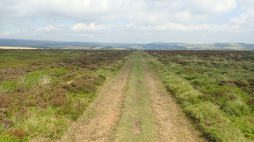
From here, the only right of way follows a blatant track. My route would complete three-sides of a square before rejoining the same road I’d just abandoned.
I considered a more direct route across the moor, as this was open access land… But the going would not have been easy and, after three days in Derbyshire, I wasn’t up for destroying my ankles on this day.

Above Crawshaw Farm, I found a space to sit and enjoy my first break of the day. It was mid-morning and, while the sheep had left their mark on every other square inch of these fields… They didn’t cause me any concern (neither were any of them dead, which made a welcome change).

Heading west and away from the farm, I would pass the underwhelming Crawshaw Wood [how many trees does it take to form a forest?] and along another way which was only visible from up close. Gorse bushes scratching my lower legs from either side.


Every now and then, I’d meet a waymark sign for reassurance. Near the top of the hill, I found one that had been broken off.
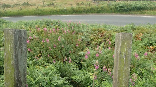
A couple of metres away from the familiar road, I found a stile with nothing less than ‘vegetation’ impeding my way forward. I did find a “path” veering right and then left to get down to the road… Just as a cyclist slowly passed.

At the western end of this road I would continue along a byway to pass Moscar Cross Farm and then turning south to cross the A57 for a second time.

…I can now officially say that I’ve been to Sheffield! YORKSHIRE!!! Perhaps not the city centre or either of the football stadiums. But it’s as close as I have been to this often-praised city in the past thirty-four years.

Beyond the road bend I could see what I’m certain was Win Hill, standing alone to the left. I wondered how Jenny was getting on with her walk.

From here, I would begin the climb up to and then along Stanage Edge. I was surprised to read that dogs weren’t allowed on this land.

…Followed by a ‘keep dogs on leads’ instruction at the next post.

I didn’t meet any canine or human folk on the way up. From across the road, I imagined this was going to be a demanding climb but I took to it well and without losing my breath.

Near the boundary stones of Stanage End, I found this one engraved with the initials or letters ‘WM’. But I haven’t a clue as to who or what they may refer to.

Views from up here were awesome, looking west in the direction of Edale and Kinder, beyond Ladybower.

I could see why this ‘Edge’ was so popular. On a windy day, this forgotten building near the disused quarry could provide a temporary break.

There must’ve be people who’ve wild camped up here. Options for a supply of water are severely limited. Every pond or pool on the map appeared to be very still and ‘thick’.
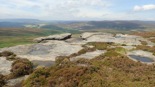
Close to where I would stop for lunch, this was perhaps my favourite photo of the entire weekend.

I’d benefited from this day of walking alone, while knowing that I would have company for the evening later.
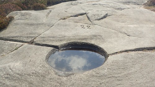
Then I saw a number ’22’… 99? 77?! If anyone can explain this to me, please leave a comment below.

20. 70? Or 90!

‘H’ probably stands for Hathersage, the town just south-east of here, containing one of Alpkit’s few retail outlets and perhaps the smallest shop in the history of Go Outdoors.


About halfway in to my lunch break, two others walkers approached from the south and decided to sit on the large protruding rock almost close to the one I was sat on. Of all the vantage-point rocks they could’ve selected…

Two other walkers emerged from the same direction, took some photos and then headed back. I allowed them to walk on before I would follow. This led to my opportunity to visit the High Neb trig point.


Ahead of me still was the official Stanage Edge, as according to the map.


I passed another shelter soon after the trig point. This one had a roof (ideal for keeping most of the rain out) and a reasonable stone seat around the inside.
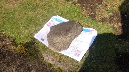
Then I spotted a few sheets of paper flapping in the gorse to my left. They looked new, as if they had only recently been printed. No heavy creases or folds. Someone had clearly dropped them. In case they came back, I wedged them under a large stone. In all honesty, they might only have been useful for the next to pass by.

Then I reached the junction with Long Causeway, where I could’ve turned left along a byway to follow the Walking Englishman’s route… Instead, I continued ahead to follow the Edge further, in the hope of bagging another trig pillar.
Around here, two other walkers (they were of young, of Asian descent and not carrying any kind of map) asked about routes heading back down to the town and train station where they had started their walk… I find it very hard to inform people who (potentially) aren’t equipped for their experience.

Perhaps I should’ve told them to search for the sheets of paper I’d rescued?
They were both grateful for my blunt direction and the male/boy tried to shake my hand… Which was awkward as I was holding a camera in the same moment and not prepared to let it go.

It was suddenly much busier towards the southern end of Stanage Edge.

…Reason being that there are two car parks close by, along a road more than 300m above sea level. People will often drive what they are not prepared to walk.
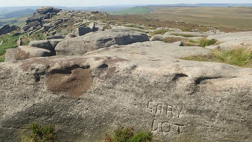
Who was Gary Dot? What is his story?

A Ramblers group passed by, on a Wednesday afternoon. I didn’t consider it in this moment but I would catch up with them again before finishing my walk.

I had to linger around (eating an apple works) for my chance to visit the trig point. On to which, someone appears to have marked the Star of David.

At 457m above sea level, this is only one metre lower than the pillar at High Neb. I can’t imagine what the Ordnanace Survey team must’ve gone through to install this one… Most are embedded two-metres in to the ground. While here, this concrete point is sitting on a giant stone.
Had I wanted to, I could’ve continued east from here, past the car parks and on to Burbage Moor in search of yet another trig point… But at what point does one stop? I could’ve continued to march across the south of Sheffield, all through the night! This would’ve taken me even further from my car.

Having taken my detour this far, I decided that I would head a short distance north-east of the trig to find the Cowper Stone, whatever that might be and potentially a strictly ‘off-piste’ cutting straight across the moor.

It’s possible I could’ve followed a line of marker posts from the car park, which almost look as though they might follow the line of a gas main. Sheep were present along this ‘way’ but there were many flies about. I would have to wade through chest-high bracken and ferns to get on to it.

Just right of centre, the woods on the horizon are where my car was parked. To the left of that, I now wanted to be on the mound of Stanage Pole.

So, I retracted my steps, passing cautiously beneath two paragliders along the way. It probably took me a good half hour to return to the junction with Long Causeway.

I don’t like walking back on myself but this would take me along the clearest route to Stanage Pole (aka. Stanedge Pole). My only concern was that I had to walk back past a few people who I’d already passed an hour ago…
I was just like them, strolling from and two one car park in a relatively short distance. Except for the fact that I was carrying thirty-five litres of kit and two walking poles!
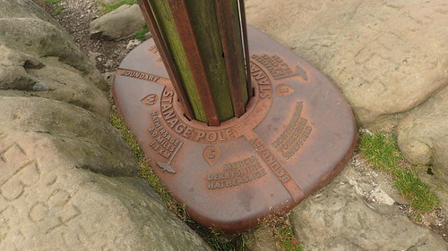

Stanage Pole is a boundary point and was quite recently renewed in April 2016. It features on the OS map as a trig point/triangulation pillar. Even without the classic stone or concrete structure, it is still an important feature and aid to navigation.
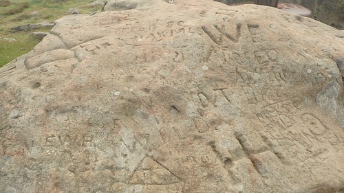
Surrounding stones are also carved with names, words and initials.
I then followed a clear path in the direction of Redmires Reservoir, where I’d begun my day. Were these the markings of the person or organisation of this path’s creator?

Does everyone in Sheffield own stonecarving tools???


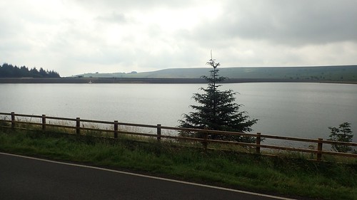
Under a more desirable light, these reservoirs looked to quite inviting. A lot of groundwork is being done around the perimeter but I’m unaware of its purpose.

There was just one other car waiting beside me in the car park. I set my SatNav to ‘Hathersage’, with an intention of visiting both Alpkit (who didn’t have what I wanted) and Go Outdoors (that shop was so small, I was out in less than twenty seconds)… TomTom wanted me to follow the “road” you see above but I knew much better!
