
Tuesday 23rd July 2019
Perhaps my biggest personal goal of this week away in Derbyshire was to explore Kinder Scout. Two years ago, I’d only made it as far north as Edale; some distance below the plateau, even though I enjoyable a memorable walk along The Great Ridge.
My goal of bagging the highest point in the Peak District was shared among the rest of the cottage and so, after a short drive to Edale, we were soon on our way.

We decided to park at the main ‘village hall car park’ in Edale, almost opposite the train station entrance but accessed from the adjacent road. It was decidedly empty, while we’d passed a number of other cars abandoned in the brief laybys and at the side of the road.

With four people in our car, there was less of a burden in the £5.30 parking fee. Add another pound for that and we could’ve stayed overnight. If you’re prepared to walk (and set off early on a weekend), free parking spaces around Edale can be sought.

We walked north along the road, crossing the line of the railway and passing The Rambler Inn on our left, followed by the local church. Beyond that was the Old Nag’s Head – a second pub so very early on – and across the road from that drinking hole… The start of the Pennine Way!
I like to think that I will one day find the time to commit to walking the Pennine Way in one hit. Although very popular, I believe it’s regarded as being one of the UK’s most challenging National Trails. At 268 miles in length and finishing over the border in Scotland, it would demand a good fortnight off work. If not a bit extra.

Treading on and in to unfamiliar territory now, we followed a footbridge over Grinds Brook. This shade was momentary.

Continuing parallel to the brook, we followed a stone path in the direction of Grindsbrook Clough. Ahead of us, two walkers veered right in the direction of Golden Clough; nestled between Nether Tor and Ringing Roger.

My impression is that clough may be a “northern” term for combe. In the same way that ‘dale’ is often used to describe what us southerners might refer to as a valley or vale.

I almost lead us up along the less distinct path behind two other walkers alongside possible the wrong ‘clough’… Before Jenny stepped in to inform me that we were supposed to cross the stream (brook) and head up through the more significant valley/clough.
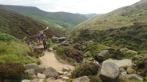
Stepping stones gave way to large stones, small boulders and the occasional wet or muddy bit.


My original plan for this route – even back in 2017, when I penned it as a possibility – was to walk the circuit in the opposite direction (clockwise, with the descent of Grindsbrook Clough to guide us towards the end).

Although this was a Tuesday, it was the first official week of the school holidays. Therefore, this part of the Peak District was still a fairly popular place to be.
We’d overtaken one group of kids (teenagers), guided by two adults. As we paused for a snack stop ahead of the final push up on to the plateau, this same group overtook us and the length of our break elapsed; allowing plenty of time for the blockage ahead to clear.

There was the option of a scrambler’s route heading north from here, along what appeared to be more of an acute than shallow-bottomed valley [sorry, clough!]. But it also looked like a longer route towards the top and there was no majority vote in favour of this route within our quartet.

One last time, we overtook half the group of kids before arriving at the southern edge of the Kinder Scout plateau.


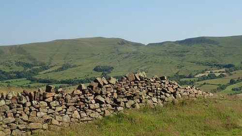
For all the bleakness of this moorland setting on top of the Dark Peak, there appears to be an easy-to-follow man-made path that skirts the perimeter of Kinder Scout.

Initially, we followed this path west for about a mile, before turning north at Crowden Brook, ahead of Crowden Tower (which I’m assuming is a hill, tor or landscape feature).

Briefly, we walked north, following the clear path on the eastern edge of the brook/stream. Both of our GPS devices then indicated a left-turn over the water, to keep in check with the public right of way that… Doesn’t appear to have ever existed on the ground!!

I find this bemusing, even though I’ve experienced it elsewhere on moorland outings. My understanding is that much of the data that Ordnance Survey records for their mapping comes from satellite imagery…
In which case, how and where did the green dashed lines for this route come from???
Our destination was Kinder Downfall, a good two kilometres to the north-west. We were in danger of trying to follow the route too precisely with the aid of technology, in some false of discovering an actual path among this mire of tussocks, ditches and peat.
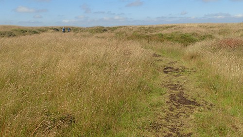
Occasionally, we would discover “a path”… It still didn’t marry up with the GPS data for the true right of way but it was pretty much headed in the right direction, for as long as it lasted.

Some way further on and we discovered the first in a series of cairns that would guide us the rest of the way. Walkers who had overtaken us earlier, filled with apparent confidence and knowledge of the way ahead, were now catching up from behind and trailing keenly in our own shadows.

This cairn-lined path was reliable and appeared to match up near-perfectly with the OS Map data. A lone walker passed us heading in the opposite direction… Seeming confident in his own walk (no map) and almost welcoming the information of the boggy now ahead of him.

I think it would almost be interesting to follow that path in the opposite direction and to see how and where it ends up… A more convenient option might be to use Google Earth!

Free from the depths of this 600m-high moor, we reached Kinder Downfall, with a view toward stopping for lunch.


An impressive view of Kinder Reservoir.
Not a million miles from here, the spillway of another Peak District reservoir has seen its spillway begin to collapse, with the immediate threat to life having led to the evacuation of Whaley Bridge. I sincerely hope that the dam does not give way and that no lives are lost in this terrifying and unsettling situation for local residents.

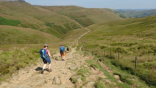
After lunch, we walked south along the western edge of the Kinder plateau, now following the Pennine Way – although there were no signs of National Trail acorns to indicate this.

Some may feel that the presence of stones (which do help to minimise erosion) detract from the otherwise wild and rugged experience of such a moor. Others feel the same way about waymarking and finger posts… Which may explain why not one was present.
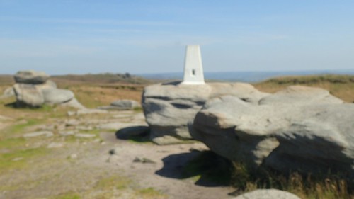
We found our way to the trig point at Kinder Low, easily enough – even though my camera was reluctant to focus properly. A mountain-mighty 633m above sea level.
Thanks to Wikipedia, I’ve learnt that the true high point of Kinder Scout is about 500m north-east of here, a non-descript plot of land 636m above sea level.


I can’t imagine this being a place where one would like to linger on a day of bad weather and high wind. For someone first steps along the Pennine Way, it offers quite the challenge to reach these heights.
Walking south to an obvious cross-paths with a bridleway (incidentally, the Pennine Way is not a bridleway… I was pissed off to see a lone cyclist around Kinder Downfall), we turned east to follow the still-unsigned Pennine Way.

At a pink-topped cairn, we followed the sign for Jacob’s Ladder.

As you might expect, it’s a series of man-made stone steps. Although not as refined as those at Cheddar Gorge in Somerset. I never enjoy walking down these, for the complaints from my knees. I’m much happier climbing up a set of steps.

We crossed a small brook via a footbridge and found ourselves shadowing a dispersed group of day-walkers, all destined for Edale. I hadn’t studied the map closely but knew it couldn’t be far, now…

Three others paused for ice cream at Upper Booth, before swiftly marching on (and eating simultaneously), as we realised that same group of kids we’d seen in the morning were about to set off along the same route… We didn’t want to get stuck behind them again!
There was an unexpected ‘up’ to the route, where I’d imagined nothing more than a very gentle decline towards the Old Nag’s Head, if not a perfectly level walk the whole way. Apt views of The Great Ridge and I could see the snaking road we’d followed between Mam Tor and Rushup Edge.


Regarding the footpaths I’ve also noticed that rights of ways in upland areas can often not exist on the ground. I find it is best to aim for paths where there is a track marked on the map, or in areas of open access just look for the tracks (grey dotted lines) on the map rather than just the green footpaths. The area around Edale is fantastic and it looks like you had a brilliant day to be up in the hills.
I’ve done some of the Pennine Way myself. From Edale to Thornton-in-Craven (near Skipton) and a few unconnected sections further north. In fact i did a part of it this weekend. I hope to do the whole walk eventually but as you say it will take a long time (I think even 2 weeks is optimistic!).
LikeLike
Hi Jon,
That’s an interesting observation. I’m familiar with places like Dartmoor, where they may not even be “paths” of any kind. But when it appears on a map and in green… I like to have some faith. I wondered how it was recorded and why the date has clearly not been updated? Yep, those grey dotted lines seemed to be much more reliable and accurate up on Kinder Scout. It was a great day, regardless. One of my highlights was the gradual climb up Grindsbrook Clough.
I shouldn’t be too surprised to learn that you’ve already walked some of the Pennine Way. 😉 I only suggested a fortnight as I’ve read accounts from people who seem to average sixteen days. I think a 268 mile hike is ambitious under any circumstances and here we are, this week, with the news that the Cambrian Way is available.
LikeLike
I it was my intent to up there last weekend but ended up visiting the blue john caves and Mam Tor instead. Lovely day….Kinder Scout next time.
LikeLiked by 1 person
Sounds like you still had a great day but I hope you can make it up Kinder another day. Thanks for your comment.
LikeLike