
Monday 20th July 2020
I remember this as being one of those Mondays (I work Saturdays and get Mondays off) where I was in two minds about going out for a walk. It was sometime in the mid-afternoon before I finally left home and drove out to Christon, a small village between Bleadon Hill and Crook Peak.
This was not one of my own routes but one I found within the excellent series of Beyond Bristol books.

As instructed, I parked my car outside the church in Christon. There was probably room for a couple of other vehicles but I wouldn’t encourage a group load of people to begin a walk from this quiet and rural location with its narrow roads to nowhere.

I don’t believe that I followed Robin Tetlow’s route with precision. There were sections where I walked his route in reverse and I possibly did this in the beginning, following the dead-end road up past Manor Farm.

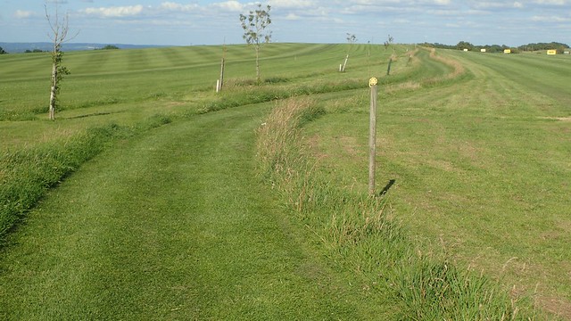
This lead me to a field with a couple of footpath options. My way forward involved sticking to the left-hand boundary, most of the way.

Gaining a little height and turning the corner, I could look back over my right shoulder and admire a more familiar sighting of the Mendip Hills’ western ridge line.
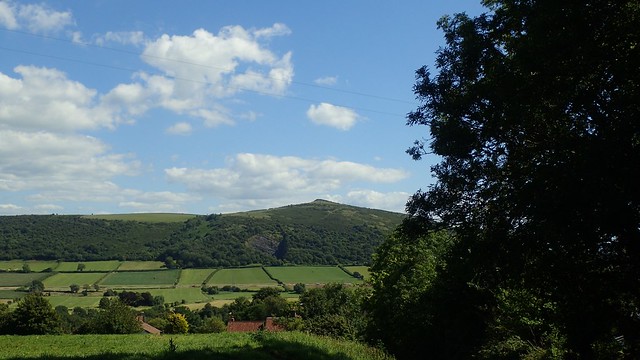
To the right of them was Crook Peak.

Rocks were scattered across this landscape with no apparent intention. There’s possibly a history or former industry that I’m unaware of.

Following the sunken track, I didn’t initially spot the cattle lurking overhead. But they offered no threat. There was no danger. I walked on.

Towards the track of Flagstaff Farm, I could see Weston-super-Mare; the town of my current home.

Heading west now and, despite temperatures of something around 20°C, I almost plunged in to this bottomless puddle. Apparently it is ever present, all year round.
An ‘avoidance route’ has been created to the north of it. I imagine this has been created by human traffic over a period of time. I always find interest in such occurrences.

Plodding on along dry farm tracks and this was probably about the time that I’d usually be settling down for a cup of tea at home.

Past Christon Plantation, I met a junction with the West Mendip Way that I knew I’d be returning to later on in this same walk. Someone had mislaid their glasses during another walk and another soul had decided to set them atop this post… In case said glasses-wearer returned in hope.

I haven’t seen many abandoned pairs of glasses in the countryside. As a glasses-wearer myself, I wonder whether they’re the top of person who wants to believe that they “don’t need to wear them all the time” and that they pack them for a walk… “Just in case”… Hopefully they weren’t also trusted with map-reading and navigation duties on that day.

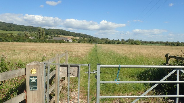
Soon after this, I left the tracks to follow an uncanny bridleway across fields towards Shiplate Slait (an SSSI).

At the beginning of what would be a long descent towards the next road, I could see Brent Knoll rising about the Somerset Levels before me.

I’d walked along this bit only once before; heading in the same direction and following a shorter route from a book known as 8 Wild Walks Across the Mendip Hills [Note to self, I once lent this to a friend and it’s moved away with them]. It was good to see the orchards still in bloom (if ‘bloom’ is the correct word).

At the bottom of this hill, I’d cross the road and follow the right of way past Shiplate Manor Farm. I somehow missed the next kissing gate (it was more obvious than I’d realised) and began trying to plough my way through the mess of nettles you see above… Before spotting an enclosed path away to my left and crawling between small trees to get on to it.
Earlier this week, I led my walking group on a five-mile route that followed this section back towards Bleadon. Please know that I DID spot and use the kissing gate. Nobody got down on their knees!

Continuing west towards South Hill Farm, the right of way was quite clear and easy to follow.
I often hold reservations about walking public paths close to and across farmland. In truth though, I’ve had very few negative experiences compared to the good; I just seem to hold on to those memories.

My memory warned me of a “very muddy field” – the kind of experiences after which, you decide to invest in ‘those things called gaiters’. But my OS map (purchased in 2012/2013) is now out of date, as some of the routes past the farm here have been legally diverted.
There was no traipsing through mud. No cautious walk through the farmyard, looking forward the word ‘FOOTPATH’ painted on to one wall!

Knowing that I was very close to the River Axe now, I decided to forget about the route I was supposed to be following and instead walked south to pick up the riverside path.

Crossing Bleadon Bridge, I realised I was heading towards the A370 and that this would mean an unpleasant walk alongside the busy road before heading in to Bleadon.

Speaking of Bleadon… I was now some distance from Bleadon Hill. It was getting close to “dinner time” for the average person and I would still have to head back up there before my day late afternoon/early evening was done.

Where the A370 passes over the River Axe, a sluice gate has been installed to control the water’s level, before it flows out in to the Severn Estuary.

Quite ancient in its appearance. One day, it’ll probably feature in the museum of Weston-super-Mare! One blog post I’ve read suggests that it’s “a bit knackered” and doesn’t maintain the water level as well as it used to.
Just up the road from this was a small parking area where people like to leave their cars. On group was removing a kayak from their roof bars with obvious intention… Presumably oblivious to the idea that all waterways are private.

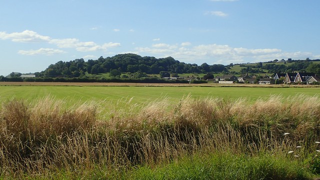
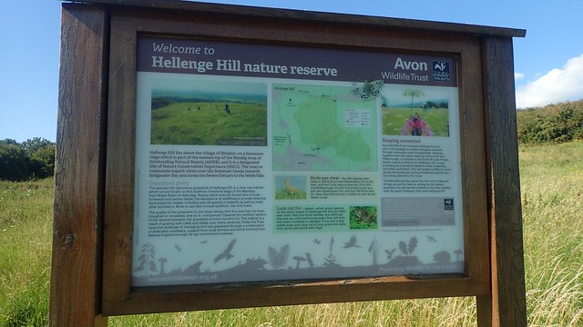
I wasn’t on the A370 for very long at all and soon turned up a quiet road leading in to Bleadon Village. I should’ve emerged from beside the church… (As I did successfully a few evenings ago)… But then, I was on my way up Hellenge Hill since my only previous visit in 2012 or 2013.
Well, it wasn’t quite as steep as I’d remembered. It’s not quite a ‘walk in the park’ but there are far greater hills on Mendip – and even those aren’t terribly tell when compared to other peaks around the UK.

Nearing the top of the hill, I passed a pair of shifty-looking individuals (well, one looked very shifty) sat on the grass. Someone before them had scorched the ground with a firepit or barbecue close by. As I passed them, one said hello, while all I could focus on was the sudden stench of weed!

From the top of the hill, I’d pass through a kissing gate to reach the Roman Road that crosses Bleadon Hill (and it’s many vast and expensive houses). But on the other side of this gate, two families had parked their cars right beside the gate…

They could argue that the nearest parking spaces were a mile away. Either way, obstructing gateways with one’s vehicle is a big no-no. I can never understand why people think it’s okay.

All moaning aside, there are some pretty good views of the Levels from here. On a good day like this, you can clearly see out to Brean Down.

Left and bit and over the road, I was heading towards Bleadon Hill Golf Course. On my recent evening walk, someone shared their memories of this land in its pre-golf course existence… Fields upon fields.

Just as I found on my first walk here several years ago, this right of way is very clear and easy to follow. There are the usual warnings of flying golf balls but there is no uncertainty to be found. Honestly, I have a lot of respect for the owners and groundsmen of Bleadon Hill.
Many other golf courses should take note!

Another view of Weston. Somewhat closer to home, high above Hutton. Yet still a fair distance from the end of my walk.

Leaving the golf course, this public right of way continues through the woods of Hutton Hill before reaching the road of Canada Combe.

It was in these woods that I dug in to my selection of snacks (thanks, Aldi). Fuel to keep me going along the final miles. Close to 18:00 now; I might or might not have a proper meal when I get home.

There was even time for tea, as I perched myself upon this abandoned (punctured tyre) pieces of agricultural equipment.

Upon reaching Canada Combe, Robin Tetlow directs you to turn left and then right, following a private lane past houses. Now, this lane is not a public right of way (as far as I’m aware) and, having past the other end earlier on, I’d noticed that it is now gated with ‘Private’ signs at each end…
I didn’t dare risk walking along it. Although it’s probably fine and, obviously, Robin must’ve done this with success. Hopefully other more socially-courageous followers have had no issues with it.

So, I stuck to the road for a bit; climbing up Canada Combe and noticing litter on either side. This must’ve been before I started collecting other people’s litter on my walks.

 At the top of the combe, I’d rejoin the West Mendip Way (a section I know well) and make my way to the junction I mentioned earlier.

With a near-level look across the landscape to Crook Peak, Wavering Down and others, I knew that it was downhill from here.

On the way down to Keeper’s Cottage, I thought I passed a runner who I knew from social media… But no exchanges were made. It’s hard to be right in such situations. I also realised that they were no longer following me (if they were, indeed, ever) and so, I gave a mutual ‘unfollow’.

Anyway. I soon arrived back in Christon and close to the Parish Pump. A short walk along the road and I’d be back at my car beside the church.
A good evening/late afternoon walk. I hadn’t wasted my day and would feel better about having to return to work in the morning.

Aren’t those stones on Flagstaff Hill the remains of a circle?
LikeLike
I’ve also heard this but not sure whether it’s ever been confirmed.
LikeLike