
Thursday 25th March 2021
In another effort to Stay Local, I drove a few miles to the village of Congresbury, with the idea of following a few footpaths around and alongside the River Yeo that I’d not walked before. Even when I used to live much closer.

I was conscious of potentially being ‘outed’ by locals for having driven a few miles (still in Lockdown at this point) in order to do this walk. So, I parked up by St. Andrew’s Church in the village. It’s away from the main road and, once I was walking, no-one would be able to tell where I was from.
Through the churchyard, I made my way along a familiar path to the Strawberry Line (formerly a light railway; now a cycle route) which I would follow back over the A370 I’d travelled along.

I even walked past this sign for the path that connects Cheddar with the train station in Yatton. I made this sign in 2020 and this was the first time I’d seen it in situ. Another one exists in either Winscombe or Sandford (I forget now).

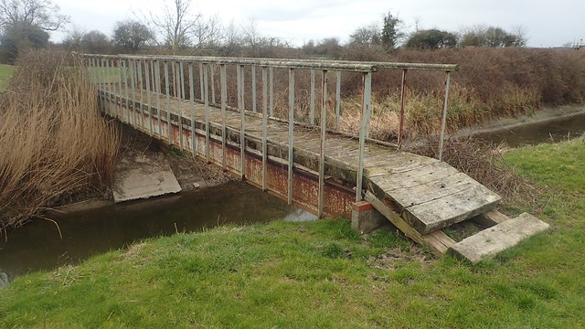
Being a cycle path, this route is easily to follow as it crosses the river at Moor Bridge.

Southern edge of Yatton. Several footpaths connect the village to the Strawberry Line.

Without treading too close to Yatton, I would soon turn off the cycle track and follow Gang Wall – ‘gang’ being an old word for ‘going’ (thanks to Simon on YouTube) and nothing to do with ‘Yoofs’ or crime. I guess this would’ve been a well used route between Yatton and the Yeo, if not Hewish.

At the end of this path, I met a junction at Pilhay Bridge. Had I crossed over, I could’ve then followed a right of way beside a company I used to work for (marked as ‘Works’ on the OS map).

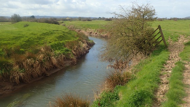
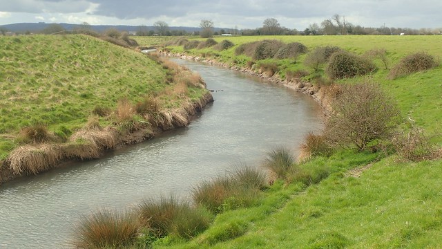
My course would turn north and follow the edge of the river for the rest of the morning.

But away to my left, was this Bristol Gate (kissing gate inside a field gate). According to my map (current and historic), there has never been a right of way along here… But its presence suggests that you could follow the northern bank of the Yeo back to Moor Bridge. On another day, I may return to find out.
I should clarify that this river is the Congresbury Yeo in North Somerset and not to be confused with the River Yeo (also known as the River Ivel) much further south in Somerset. Unlike many other rivers nearby, this one’s course has probably not been altered by man. All we’ve done is to build and raise the banks and flood-defence levees on either side.

I continued walking west past Pilhay Farm. It was easy going and I found the occasional marker for the Round Yatton Walk.

At the end of Wemberham Lane, there’s the option to turn right and follow it in to Yatton’s north end. I could’ve continued ahead and on towards Kingston Seymour. But I turned left, still following the Congresbury Yeo (and the chain was removable thanks to a carabiner).

Waymarkers become less frequent – and perhaps they are unnecessary, as the path ahead is formed by a raised bank of earth, somewhat inland from the water’s edge. Perhaps this is also a way that people have been travelling for many years. I can imagine standing water being an issue on these plains through the wetter months.

This location is clearly marked on the map as being the former site of a Roman Villa. Excavations were carried out in the late 19th Century, when your typical Roman remains were discovered during work to lay pipes through this field. Of course, nothing remains Wemberham Roman Villa today.

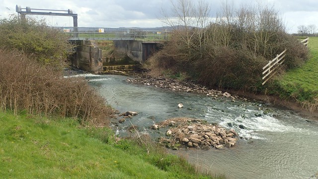
It was another one of those local walks where I found myself quickly approaching the M5 motorway. To be walking at eye-level with fast-moving traffic; I always find that a bit odd.

Then I would arrive at Phipp’s Bridge – a marker for anyone who’s attempted to walk the “coast path” through North Somerset. I last came here in 2015 with my friend Anna, on our journey from Portishead, through Clevedon and to the A370 in Hewish.
(Click here to see that old blog post.)
But I wasn’t here to reminisce over any of that. I wanted to investigate the ‘subway’, just north and potentially crossing beneath the motorway…
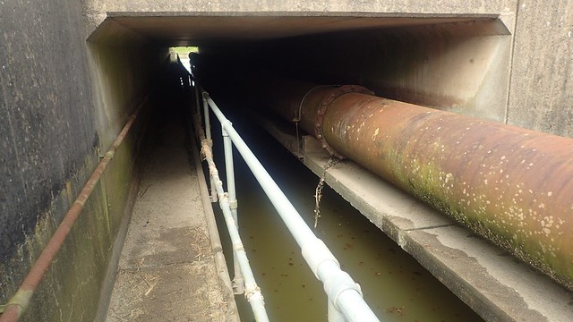
I’d first read of this on Ruth Livingstone’s blog several years ago. When she attempted to cross here [or on a similar route nearby], she found the walkway was under water (apparently this is common) and there would brambles and all sorts blocking an escape from the far end.
(Click here to read Ruth’s account.)

I hadn’t expected this walkway to be so clear. There’s something about its silence, with the concrete overhead withholding all sounds of the six lanes of traffic. Not somewhere I’d walk at night but it’s clearly unknown to those who like to tag such surfaces with graffiti.
I poked my head up from the other end and could see it would’ve been possible to walk to (or from) Kingston Seymour. Had this been cleared by the council to satisfy the year of the Lockdown Walker? Who knows!
I returned to Phipp’s Bridge before continuing my walk alongside the Yeo… Following the WRONG side of the river! I only realised this as I spotted the white van from Mendip Outdoor Pursuits – at a site near Wick St. Lawrence, where I’ve previously discovered issues with obstructed paths and no waymarking.
(On that note, thank you to Margaret who recently e-mailed me with updates and improvements to that area – I must reinvestigate it myself, soon.)

Leaving the Yeo behind, I made my way in to East Hewish and the A370.

Across the main road, I could meet again with Oldbridge River. Having spoken with Adrian at North Somerset Council about previous issues nearer to the M5, he told me how they’ve carried out a lot of work in this area previously – installing new kissing gates and waymark arrows – and I was also keen to see this for myself.

I’m still not sure why it’s called Oldbridge River… But there are several ‘old bridges’ along the way. Some of which are not open to the public.

I would follow this river past Willow Farm, across Puxton and on to Dolemoor Lane.

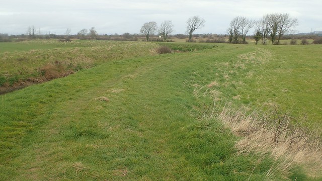
I turned south along a bridleway towards Brandeer Rhyne, where much of the riverside landscape had recently been dug up for some unknown reason. Perhaps it’s to encourage new growth? Or do they intend to lay down a surface that’s more durable for the walkers and horses who regularly use it?

A number of trees have been cut down. They didn’t look like ash to me but then, I’m no expert when it comes to identifying them!
I soon made my way back in to the churchyard and my car. It was close to lunch time and I’d soon be home for a proper break. A non-too-challenging walk. Much to have explored and more I’d like to return to.
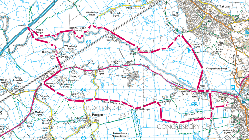
Length of this walk = 8 miles
Thanks for reading.

Wow how lovely to see your own handiwork installed in public like that. It looks a lovely sign with a nod to the railway origins.
I remember that bit of the “coast” being rather a pain to walk. I put coast in quotes because most of the time I couldn’t get very near the coast. Even then I recall the path I did follow was not well signed at all and found temporary electric fences across the line of the path. It did not feel a friendly place to walk.
LikeLiked by 1 person
Hi Jon,
Thanks, it was quite nice to see it up and in situ. It was an almost like-for-like replacement as the previous sign had rotted away.
“Coast” is the only way to describe it! Sounds like you caught the full experience. I’m still optimistic that the almost-coastal cycle route will be created this summer.
Thanks for your comment.
LikeLike
The works at Brandeer Rhyne was keeching, clearing weeds, desilting, and dredging to keep the flow in the rhyne. The mud is the silt pulled from the rhyne or ditch. It’ll grass over after a while.
LikeLiked by 1 person
Thank you for clarifying this. I’ve seen a lot of dredging going on this past year – I believe they were doing similar work near the Strawberry Line in Congresbury. All good to know.
LikeLike