
Good Friday 2nd April 2021
It was the beginning of Easter and I had the opportunity to go for a decent walk with a friend. Not entirely comfortable with the idea of restarting or resuming walks with groups of others, this seemed like a good opportunity to get out with company. Being an Easter weekend, I also decided we’d avoid the busiest areas, while staying fairly local to our homes.
We met up on the edge of Wedmore – there’s a free-to-use car park with plenty of spaces off the B-road heading downhill from Cheddar. I’ve walked from here on my own before and have held ideas about hosting group walks here.

I won’t drone on too much with the trek across Wedmore Moor. It’s very similar to the beginning of a solo walk from last summer [see this blog post]. This time, we’d walk a little bit further north-east and climb higher, up to the Mendip ridgeline.

Just outside of Draycott, we crossed over the line of what is now a disused railway. Lost to the undergrowth. Hopes of seeing it salvaged and revitalised as an extension of the Strawberry Line cycle route seem further from reality.

We crossed the A371 at Rodney Stoke and this picturesque point near Scadden’s Lane.

Nicolle didn’t hesitate in taking to the tyre swing and certainly enjoyed her time.

Beyond the waterfall, we began our ascent up to Rodney Stoke Nature Reserve. These woods why known by another name until a few years ago (possible Stoke Camp or Big Stoke – I cannot recall now).

This may make more sense to people who watch one of my future YouTube videos… But I regard this climb as being one of the FOUR toughest ascents/descents in the Mendip Hills.
(Others include the staircase of Ebbor Gorge, the start of the National Trust’s Cheddar Gorge Walk and Batcombe Hollow – which you’ll soon see further below.)

At the top of this field sits a very convenient wooden bench. Fallen logs nearby allowed us to sit comfortably together and yet with a good social distance.

Immediately after this short interlude and snack stop, we continued up through the woods – where I’m convinced the gradient of the hill increases by at least five per cent! From the top, your reward includes this view of Cheddar Reservoir and the hills that define the West Mendip Way.

There are various permitted paths around Rodney Stoke Nature Reserve that I’ve not explored. One can also take a detour east to Westbury Beacon.

We were walking north on to Draycott Sleights. Another nature reserve, with an airfield and gliding club sitting over the next boundary. A few parking spaces are available in the road close to the Sleights, for those not accustomed to walking up hills.

A lot of open land lies beneath these hills and yet, fewer people seem to travel out this way. As of perhaps two years ago, the West Mendip Way has been redirected to run across the Sleights. Before then, it would take a sharp plunge down in to Draycott village… Almost immediately followed by a cruel ascent to regain every millimetre of that lost elevation!
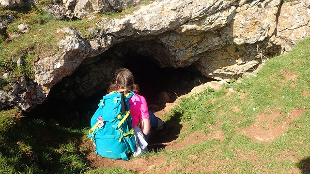
We followed a vague path along the top of Draycott Sleights. It’s one I’ve walked several times on my own and yet, I’d never spotted this cave before.

Armed with an inferior headtorch, I ventured in as far as I might dare…

…Which meant stopping at the point from which I’d have had to continuing in a horizontal position! Where the earthly scent grew strong and the ground beneath my heels felt increasingly damp. I couldn’t see the furthest end of this cave but it went on for a good distance further.

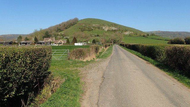
After lunch on the windy hillside, we would begin our descent towards Nyland Hill, which you can see as the wood-lined lump in the photo above. Look closely and you’ll also spot the road that led us most of the way there.

This is the aforementioned Batcombe Hollow. Each year, when I undertake in the annual Mendip Challenge (as I’ll soon be doing in June), I followed the right of way up and around this curious and punishing valley. It’s worth knowing that the only right of way does run up and around it; not straight up the middle.

We debated as how this valley or combe might have been formed. Above and below, large standing stones can be found and clearly mark the way. With that comes a suggestion that people have been travelling this way for many years.

Following the road along Latches Lane, we again crossed over the disused Strawberry Line.

Moments before our climb up to Nyland Hill, a car pulled over close to us. From the passenger’s window, a lady asked whether I make YouTube videos… Which I do. But I was starstruck! I didn’t know what to say or how to respond. Completely unexpected. While also appreciated. It turns out this lady used to live near by, was revisiting on the day and had recently seen my video from another walk close by.

One side of Nyland Hill is covered in woodland, with a strong carpet of garlic at this time of year. It’s all private. Fortunately, the half with the trig point is free for open public access. Many liken the hill itself to the head of a balding man…!
Nicolle highlighted some of the local wildlife that I’d have missed otherwise.

Following the sharp descent off of Nyland Hill and towards Quarry Farm, I was wanting to following a path I’d not successfully walked before… On my only previous attempt, I had a “bull” run at me (from the far side) as soon as I set foot on his land… I bottled it and followed the road back to my car.
From Decoy Pool Farm (ST 455 505), we walked west across the first field, absolutely filled with sheep… Only to find that there was no way to cross through the next boundary. Any right of way had been fenced off. I had the GPS going on my phone to confirm the location and there was no alternative within a few metres either side.
I didn’t take a photo but it looks as though this footpath has been obstructed. While reporting it online via. Somerset County Council’s website, I learnt that I’m not the first to have encountered an issue here. An automated response informed me that it’s already being investigated.
So, it was back to the road of Nyland Drove (above). Not at challenging but extremely tedious, at times. I did think about trying to venture beyond that first gate but there was no suggest of what may or may not have been waiting ahead.
Length of this walk = 10.75 miles
From the village of hamlet of Cocklake, we followed footpaths back to the car. A good day in all, with shared company and a circular route I’d not already covered in its entirety.
Thanks for reading.
