
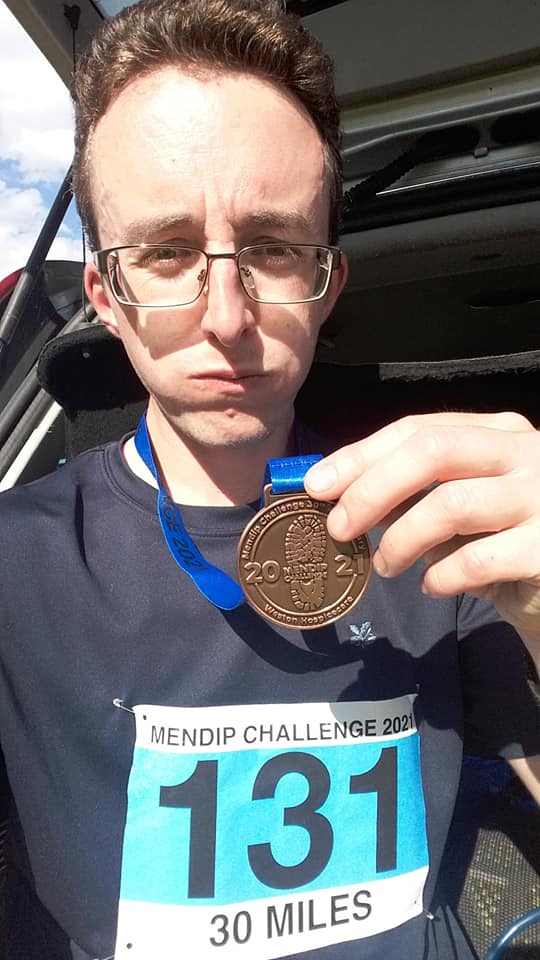
Sunday 6th June 2021
Having missed out in 2020 due to the pandemic, I was pleased to be able to take part in the Mendip Challenge for the seventh time. Last year, Weston Hospicecare did organise and host a lesser ‘Mini Mendip’ event… But to be honest, I didn’t have the greatest of interest in that one and was keen to defer my entry until this year.
I’ll be honest… In the hours running up to this year’s event, I was not looking forward to it. This was largely due to how I was at the time, having not had a particularly great week beforehand. I could’ve quite happily “overslept” or stayed in bed too long. I didn’t sign-in on the morning until five minutes before the deadline of the given forty-five minute window.
Truth be told though; deep inside, I knew that I would’ve regretted missed out and not having seen any of the few people I knew would also be taking part.
At my count, there were four coaches put on and waiting for the 30 mile participants so early in the day. I walked on to what I believe was the third coach to depart, at around 6:45am and we arrived at the drop-off point in Wells no more than an hour later (although I didn’t check the time).

For this day, the forecasts had strongly predicted rain. From warnings of ‘heavy rain’ on one day to ‘light showers’ the next. I’d packed waterproofs. My rucksack’s raincover was ready to deploy and… With all this mist and murk hanging over this morning, it seemed inevitable that four coach-loads of walkers and runners were going to get wet.

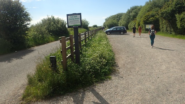
Following the route guide [always follow this rather than other people], we made our way from Wells, through grounds of the Blue School, following the West Mendip Way through Wookey Hole. I took a blurry photo (above) at the base of a set of unforgettable steps for the climb up and out of Ebbor Gorge.
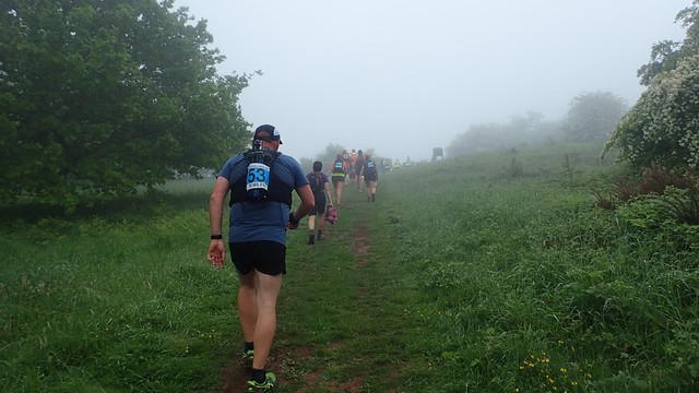
About halfway up, I met one of the friends I’d not already seen that morning, due to my late arrival. She was hunched over, hands on her knees and feeling unwell. I felt bad in leaving her but wasn’t sure of what more I could do, other than to press on and inform her sister, who was waiting at the top (good news is that they both went on to complete the walk).

From the top of the gorge and still within the mist, we marched on towards Priddy. Stiles made of stone and sometimes wood encouraged people to slow down and gather almost as a whole.

Shortly before the end of Pelting Drove, I passed my first checkpoint of the day, in the car park for the Queen Victoria Inn. I was recognised at this point, by a man who I now know was Terry and one of the original organisers of the event thirty years ago – hello, Terry, if you are hopefully reading this!

When I was last doing this walk in 2019, I moved to overtake a couple of women when one of them turned and said ‘Olly!’ We’d not met before but she’d also recognised me from my blogs of this yearly event. Then the year before that, a guy I briefly walked and talked with (dubbed “Umbrella Man” by a few) later realised that he also recognised me from my blogs.
On Sunday, I overheard a couple of others refer to “this guy’s blog” but none were able or forward enough to match my face.

Crossing the farmland plateau of Mendip en route to Draycott, the cloud was beginning to lift.

I’ve seen many seasoned walkers and Ramblers freeze or go weak and the knees, when faced with even a small herd of cattle. But on a long-distance outing and with that determination to finish, it seems those fears may be less prevalent.
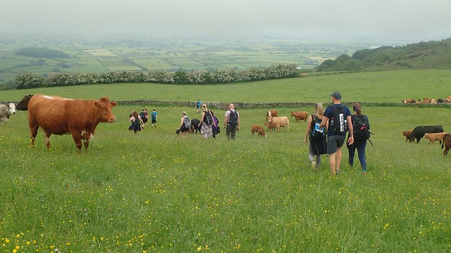
I did feel a bit uncomfortable, watching (and then following) many other walkers straight through the herds, where we probably should’ve walked around… But these cows were spread out all over the right of way and no incidents occurred, to my knowledge.

It was then that we could see so much of the Somerset Levels, Nyland Hill and even out to Brent Knoll.

But it looked as though some form of storm or shower was imminent. We could look ahead, beyond Cheddar Reservoir, to Wavering Down and Crook Peak; the route we’d be following through the afternoon. In spite of the scene and potential for a downpour, I did enjoy walking in such a cooler temperature.

In previous years, the walk would now take a sharp drop in to Draycott, following the A371 for a moment, stop outside the cider barn for a mandatory checkpoint and then, begin the almost never-ending ascent up and around Batcombe Hollow…

But the official West Mendip Way was redirected in a few areas, only a couple of years ago. Above, you can see the more leisurely walk of a tree-lined path beside Draycott Sleights Nature Reserve. No great loss in elevation; on a brief incline at the other end.

Those darkest of clouds came to pass, as we marched on with Cheddar in our sights. I would previously have stopped for a ten minute break down in Draycott, ahead of the punishing climb back up to this level. But for now, I was happy to press on.
(For what it’s worth, the 20 mile option of this walk begins at the cider barn beside the A371 in Draycott…)

This year, the yellow signs and additional waymarking from the organisers was particularly excellent and very frequent. I would almost say that one may not require a written route guide… Almost!

From Bradley Cross, the Mendip Challenge still follows the former course of the Mendip Way; up to and across Bubwith Acres Nature Reserve. It’s the tough climb I used to forget about in my first few years; thinking of only Batcombe Hollow. Some stopped for a deserved rest near the top of the ascent. I’m a reasonably fit (and sometimes fast-paced) hillwalker and this is one of the toughest sections of the entire route.
More recently, the West Mendip Way has been redirected towards the lower village and tourist-end of Cheddar Gorge. More convenient for basic supplies and accommodation. This route then continues up and along the north cliffs above Britain’s biggest gorge.

I’ve not seen or read any official word on why only a portion of this challenge walk has been updated. I can only assume that crossing the B-road at Black Rock makes for a convenient space in which to set up a manned checkpoint (the first I’d seen since Priddy). Where as, down in the hub of the gorge with restricted parking and people milling all over the place, it would probably be harder to put in to place.

Before descending to cross the gorge road, I could see Black Down and Beacon Batch on the horizon – the highest point on the Mendip Hills AONB. I still find it a bit odd that the West Mendip Way bypasses this, in favour of a lower road.
We follow the second of the National Trust’s Gorge Walk (but in reverse) on the way down to the road… Shortly after beginning my descent, I noticed a young woman who’d fallen and twisted her ankle. She was in considerable pain but, without any Outdoor First Aid training, I wouldn’t have known what to do… She had plenty of friends around her and someone else had stopped to enquire. I hope they all made it home safely, whether they were part of the same walk or not.

Over the road towards Black Rock and, again, further evidence of ash dieback. This area was closed to the public back in December or January while the work was carried out.


I had a five minute tea break, sat on a large rock a bit further on. Then it was up past Long Wood, ignoring Velvet Bottom and around Charterhouse Farm.
By this point, I’d been hoping to have caught up with two more friends who I’d not seen all morning. I’d assumed they’d arrived in good time and caught one of the earlier coaches. But, having not seen them by now, somewhere between the ten and fifteen mile mark, I wondered whether they’d even made it on the day.

I remember meeting and walking with a guy here who was mostly running the event. He told me he’d also arrived late to HQ that morning and caught either the sixth or seventh coach for the 30 milers (I didn’t realise there were that many). He was mostly a cyclist, not much of a walker and sometimes a runner. Although he’d not run this distance before. He seemed to be getting on quite well and surely finished in a good time (I mean, I never saw him again).

Next up at Tyning’s Farm, a hearty round of applause greeted those of use who converged in the same moment, thanks to the friendly checkpoint volunteers. This was one of the very few portaloo stops available. I grabbed a bottle of orange and one of Lidl’s own-brand Snickers bars – the only food and water I’d help myself to on the day, as I prefer to be self-sufficient (at the expense of my back and shoulders).

Down in to Rowberrow Warren, passing a flurry of friendly horses riders heading back to the farm. Up to the other side and following the road down towards Shipham; turning left opposite the pink cottage in the photo above.

We met a couple of misdirected 20 milers in the next field and made it around the outside, correctly, with this great views back towards Weston-super-Mare. Blue sky was becoming ever-present, as the cloud continued to clear.

There was the usual hazardous road crossing beyond, then a descent in to one valley, a steep climb up steps to escape that… Ahead, we marched on towards Winscombe Drove (outlined by a pair of hedges above).

In my experience, this is normally a very wet and muddy stretch of the walk, even in June. This year, conditions were much more bearable and probably due to the recent warm weather, even after a cold washout month of May.

Over the A38 and we begin the climb up through King’s Wood, which forms the beginning of a very popular walk up to Crook Peak. Again, work was completed here in the winter, in the fight against ash dieback disease. As I’ve said in other blog posts; it really is as if someone has taken the roof off of these woods.
A number of mountain bikers passed by, heading down the rugged slopes with tree roots taking control. I’d noticed that they each had a number affixed to their handlebars and were surely part of some cycling event. Between here and the top of Bleadon Hill, I’d seen a good few more of them.

Up out through the woods, over Cross Plain and it was on to Wavering Down, bearing the only accessible trig point of the day. It was getting close to 13:30 by now. Some had sought the shade and shelter of the woods, while I wanted to make one final push before stopping for lunch.


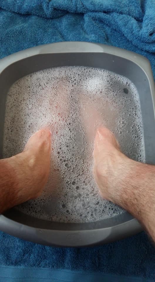
I only sat for about fifteen minutes, where I’d usually rest for a bit longer. Having taken my boots off was a treat for my feet. My socks were still soaking wet, having ploughed through some long grass earlier in the day. I’d made the decisions to go for ‘comfortable’ boots over my most waterproof… I’d packed spare socks in fear of the rain and, at this point, I should’ve at least changed my socks before plodding on.
I’m going to write a separate post about packing for such a walk, with a few tips on items that one may wish to consider. Moral of this previous paragraph is that my feet were developing hotspots that could soon lead to blisters!

I’ve never been one of those non-stop challenge walkers who eats as they go. I’m sure that I could do it, physically, but I do enjoy the mental break and taking time out (especially when the weather’s good). But there is something I find distressing about watching people pass by – when it’s the same faces I’ve already worked hard to overtake!
Above, you can see Crook Peak. One of Mendip’s most iconic high points. Please note that it is CROOK Peak and never spelt with an ‘s’. Again, on this year, I overheard too many people pronouncing it incorrectly (it’s a personal gripe of mine). The West Mendip Way passed around it. For anyone exploring this Way but without doing it all in one hit, I would strongly recommend a detour to the rocky summit.

Soon, I would have to cross back over the M5 motorway, which is a good indication that you’re well in to the final third. My heart is never full ‘in to it’ from this point on and the eagerness to finish the walk only grows stronger.
For the first time in the history of the Mendip Challenge, we cross over the “Hinkley Point Road”, which runs from the nuclear power station, across North Somerset and on its way to Bristol.

A very busy afternoon on the M5 northbound. As this was the tail-end of half-term for many, I imagine they were all making that long journey home from their holidays.

Entering Loxton, an old and always-quiet village, with Bleadon Hill rising above it. This next climb is a bit of a slog. Some 1.5 miles in length. Not too intense but everlasting.
In previous years, I’d find myself queuing behind groups of 10 mile walkers. But the 10 mile route now runs elsewhere. My main hazard this time was to watch out for those mountain bikers coming down the bridleway; giving way to them where appropriate (it’s also worth reminding people that, as according to the Countryside Code, walkers will always have the right of way on a shared path).

From the top, we made it on to the Roman Road, above Bleadon and with another checkpoint not far along. We then follow the road for a good mile before heading off. It was pretty busy with walkers (many of whom don’t know to walk on the right-hand-side of the road, against the flow of traffic – although “groups” are supposed to walk on the left). One impatient driver decided to put his foot down and speed past a number of us… Luckily, no-one was hurt.

Good views from here of Brent Knoll, the Somerset Levels, the Severn Estuary, Quantock Hills and Exmoor, faint on the horizon.
A bit further down near Bleadon, a gathering of walkers ahead of me became ‘unstuck’ when attempting to determine the correct route out of one field. It’s perhaps one area where we could do with one of those large yellow signs (grid reference: ST 341 573). Half the group wandered off the wrong way, across private land with no public access, while the rest of us followed in my correct lead (although I have made similar mistakes here in years gone by).

We continued up and around Purn Hill – not as significant as those already conquered and usually a good indicator that the finish line is night. Further down, another marshal was on hand to direct us left to the A370 (not right), where we could safely cross the very busy road at a traffic island. This is a nice touch, where marshals have previously attempted to halt traffic (putting themselves at risk) to allow clusters of us to cross at once.

Down past the railway line, following a clear path towards the Brean Down Way. My feet were shattered by this point. If they could talk… Well, they wouldn’t have been talking to me! This year, where we’d normally turn right and follow the cycle path directly in to Uphill, we’re instructed to turn left and follow an added loop around Bleadon Levels Nature Reserve.
This takes us off from the West Mendip Way and, to be honest, when you can see Uphill, almost reach out, touch it and you have only ever turned right for the previous six years… After twenty-seven miles of walking, it’s a bit of a psychological challenge (or a headf**k). Marshals are on hand to ensure participants don’t cheat or go the wrong way.

It was nice to get on to the grass bank with a clear view of Brean Down. Turning the corner, you do continue towards Uphill.

For the sake of this added loop (which I assume is to make up for the alterations around Draycott, Cheddar and to keep the 30 miles honest), I am not sure if I’ll be signing up for the same walk next year. I am interested in trying to run the 20 miler – despite having not run more than five miles to date! Perhaps after seventeen miles, this indirect return to HQ won’t seem quite as bad?

Then there was the unforeseen ascent of Walborough. I’ve since noticed that the Mendip Way officially snakes around this small hill, while I blindly followed a number of others up and over. Again, by no means the biggest hill of the day but another added extra for 2021.

Then… We rejoined the cycle path through Uphill. Local walkers cheering us on and congratulating us, as we passed through the village; up Thornbury Road, passing the former end point at Westhaven School. Over the main road and back to the cricket club.
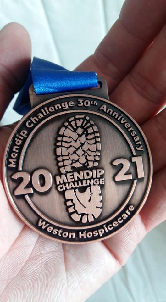
I collected my medal with a real sense of satisfaction and gratitude. This had been a hard walk. More so than I’d expected. Perhaps the year off hadn’t helped? I felt very good for having done it and, as I clasped my medal, said my thanks and turn towards the portaloos… There were the two friends I’d been striving for in the morning. Somehow, they’d remained mere minutes ahead of me throughout the day! Having not taken on the challenge herself since we met in 2015, she was extra pleased to have beaten me! 😉
My thanks go again to Weston Hospicecare for organising another excellent event and in the face of this ongoing pandemic. I do look forward to taking part next year. Whether or not I’ll be ready to run much of it, we’ll have to wait and see!
Thanks for reading.

Well done Olly.
Walking 30 miles is one hell of an achievement even for an experienced walker as yourself.
You should be very proud of yourself and give yourself a big pat on the back too!
Good luck on your next epic challenge, meanwhile, pamper those poor tired feet!
LikeLike
So nice to read this. A totally brilliant event. I haven’t done the 30 mile route for 20 years now, so it was interesting to read about the redirected parts of the route in particular, but mainly just to bring back memories of sunny days, rainy days, fierce climbs and killing descents, encouragement from checkpoints volunteers and delight on coming across the public toilets in Bleadon! Anyway, well done and power to your elbow!
LikeLiked by 1 person
Hi Phil,
Thank you for reading. It must be interesting to see how the route has changed over the years – and may continue to do so. I hope you’ll get a chance to do the 30 mile walk again one day.
LikeLike