
Monday 28th March 2022
With one walk from this trip already under my belt, it was time to embark on one of the two particular walks that I’d most been looking forward to. Having checked out of the Glan Aber Hotel in Bets-y-Coed, I drove for fifteen minutes along the A5 and in to the Ogwen Valley.
Last time I was here, in July 2018, I scrambled up Tryfan and in to the Glyderau with three friends. On this day, I was to climb the other side of Cwm Ogwen and meet the Carneddau.

There’s normally plenty of free parking along the road here, either side of Llyn Ogwen. Smaller pay and display car parks also exist. Although it’s still advisable to arrive early on a Bank Holiday or scorching weekend – only a few days ago, I saw news stories of car parked “dangerously” and illegally beside the lake.

I stood beneath the might Tryfan at the beginning of the day. He who cannot be walked and MUST be scrambled. One of my all-time favourites. I’ll surely climb it again one day.

My walk kicked-off following the Snowdonia Slate Trail past Tal y Llyn Ogwen.


I then met with and joined the Cambrian Way – probably the longest inland footpath to cross Wales, at 298 miles long. On the ground, there was a path to follow for most of the way. Otherwise, I was mostly handrailing the western bank of the Afon Lloer.

I was already gaining height before Pen yr Ole Wen. Another day, another scramble stood before me! My route this time would begin from the east. I believe there’s an alternative approach from the south – starting to the west of Llyn Ogwen.


I had no great challenge in finding my way up this one (unlike Daeaer Ddu and Moel Siabod). I’d managed to skip ahead of four other walkers who’d been headed in the same direction.


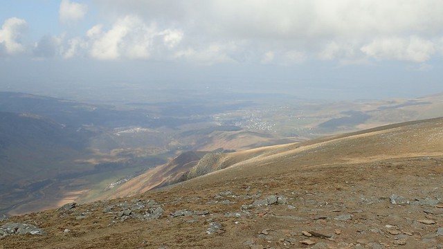
I was gaining elevation as the minutes passed. Across the valley to my left, I was almost level with Tryfan, which rises to 917m above sea level.

My knee would gently remind me of the pain that began on the previous day. But I was enjoyed this route much more and without following any line on a paper map or electronic device.

There were even a couple of points where I found myself having to climb and not scramble up rocks. Perhaps you can see that in the photo above. My only rule thus far was ‘don’t stray too far to the right (north)’, or else I might risk a deathly plummet.


Another sunny day to be on the summits. Although the MetOffice had forecast that fog would cover the higher tops before midday.


A flat cairn marks the summit of Pen yr Ole Wen, at 978m above sea level. Somewhat taller than Tryfan.

I almost had the summit to myself. But for a couple of others who’d possibly followed a more leisurely route to the top. No breeze to be felt or heard either.

From here, the way onwards was clear; follow the blatant ridge to Carnedd Dafydd. I could see a couple of walkers ahead of me, who I’d also overheard were more used to walking in the Lake District.

Some of these mountains are the equivalent of urban parks, for those who live close by. Many will tell you how “The Welsh” (especially further north) will hate and resent “The English”. But up here in the mountains – and on many other summits – I see and hear nothing but friendship and open kindness.

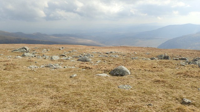
Small cairns adorn the path from the stone stock on Carnedd Fach, all the way to Carnedd Dafydd. If this fog was to fall and suppress my field of vision, I still had half a chance or moving on in the correct direction.


I passed a friendly dog walker, enjoying the view back to Pen yr Ole Wen, before I arrived at the wind shelter on Carnedd Dafydd (1044m above sea level).

I sat down away from the shelter, taking in this view of mountains… Probably look at Snowdon or very close to it.

While enjoying my hard-earnt cup of tea, a pair of walkers emerged from behind me (and from absolutely nowhere) and took their chance to sit inside the shelter. Both were fluent Welsh speakers, I could tell you that much! I’d end up following them for the next mile or so… It felt quite long, trying to maintain a distance.
I realised it must be nice for the two of them to be able to chat so comfortably using what is possibly their mother tongue. But when it came to it, they were as happy to snap in to English; having crossed another couple of walkers who also happened to live in Beddgelert and debating, whether they both knew the same “Gareth Evans” (eavesdropping, I learnt that there are only two Gareth Evans’ in Beddgelert…).


My walk continued on towards Carnedd Llewelyn and the highest point of my day. Still also following the Cambrian Way.

A sense of mood grew as I reached this summit (1064m above sea level). There was still no sign of the impending fog and it was already some way past lunchtime.


I was following a route I’d found on OS Maps and from here, it includes a diversion north-west to and then back from Yr Elen. I didn’t bother with this; that mountain and others will still be here in the future (they’ve survived the pandemic).

My own thoughts had considered venturing north to Foel Grach and even beyond. But again, they’ll still be here in the future and I was quite keen to get back down before dark, knowing that I’d then have to settle in to my next accommodation.

That meandering path from the summit was unwelcome. My left knee was not best pleased. But staying put wasn’t an option. There was even the glimmer of a suggestion that rain could arrive.
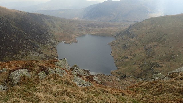
I followed my way to the mountain pass, Bwlch Eryl Farchog, looking down over the reservoir, Ffynnon Llugwy.

I had to shuffle and down-climb in places, to get to the top of this pass. Before heading any further downhill, I stopped, sat down and fuelled myself with what was left of my food. Very wary that my left knee was sore and that accidents can happen when heading down from high places.


I made it down in one piece and without incident or injury. Please to reach the smooth road that I could follow back to the A5. This would lead me further downhill. But the descent was shy of knee-jarring rocks.

Another impressive view of Tryfan, as I bowed before the hallowed mountain.
In my car, I would drive south through Blaeanu Ffestiniog and, some forty-minutes later, I would arrive at the bunkhouse for my final three nights. On the way, I stopped off at Betws-y-Coed for one last time and bought a pizza for dinner.
Pleased to have met and conquered the Carneddau. I’d happily climb Pen yr Ole Wen again and know that many other summits exist further north.
Length of this walk = About 10 miles
Thanks for reading.

Thanks Olly. Another great read and some nice scenery pics too. 👍
LikeLike