Monday 27th May 2019
With a full weekend of walking behind me, I awoke with a feeling of fortune; knowing that I could otherwise have been working on this Monday morning, like millions of others around the UK.
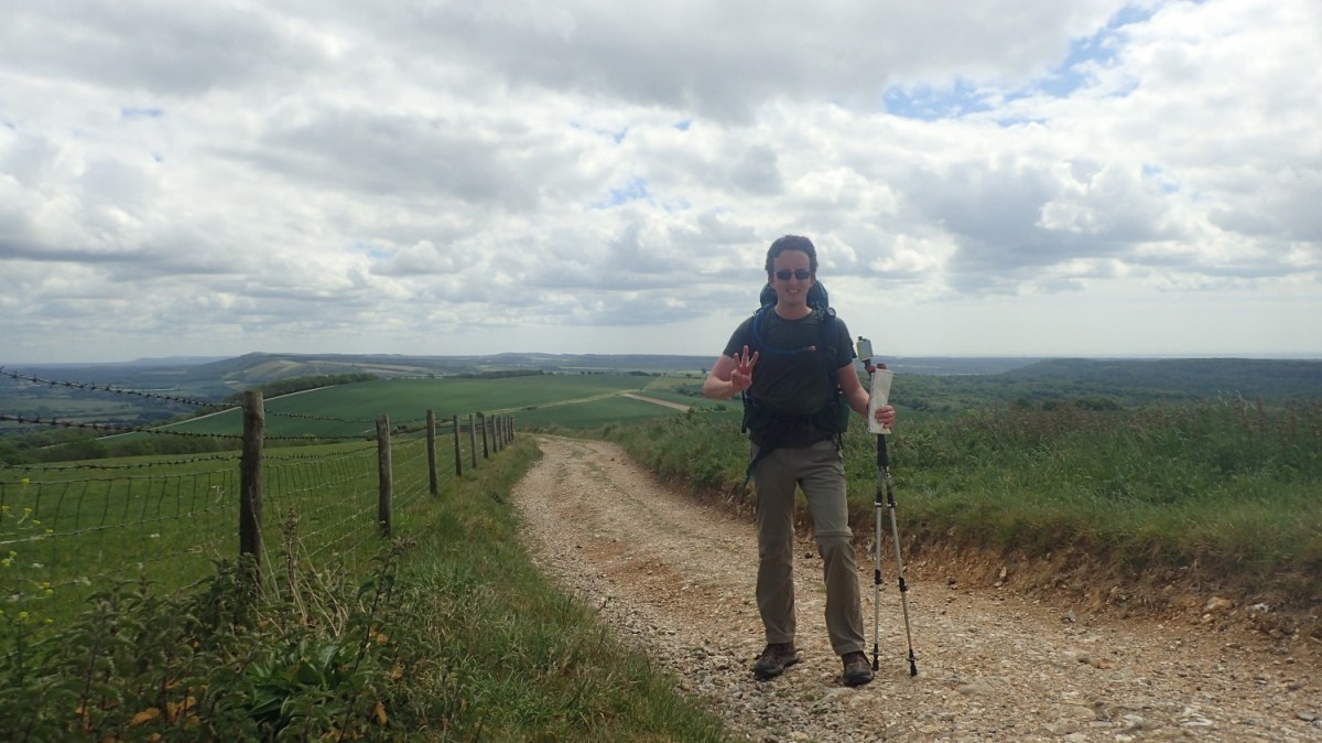
Feeling refreshed the morning after my first shower on the trail and with my rucksack feeling significantly lighter without two evening meals, I felt as though this was going to be a good day following the South Downs Way.

I was up before 7am and looking to get breakfast on-the-go… Just before my neighbouring pair of backpackers with tidying away their tent in preparation for an early start to their day (a few days on from this, I would learn that Day 3 was to be their longest of the week).

Those noisy kids were still locked in their tent at this hour. Barely making a sound. I looked forward to leaving them behind… I spoke briefly with the mother, who I think told me that they were cycling the entire South Downs Way… Except, the kids had been complaining and their day was expected to be cut short at Amberley, from which they would catch a train to Lewes (I mention this because it is significant).
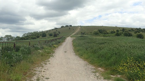
Day Three began with the familiar and steep climb up above Manorfarm Down. It actually didn’t feel too bad, the morning after.

Beyond the familiarity of Heyshott Down, I would cross Graffham Down.

There’s a lot of archaeological history close by, with a series of tumuli (burial mounds) visible from the main path. I read on another information board that the South Downs bears more than its fair share of such earthworks.

Speaking of Graffham… My original plan had involved staying at one of two possible campsites in the village, which is a good 3 miles (one hour’s walk) north of the South Downs Way and a fair distance beneath it. In that sense, it was fortunate they were both fully booked by the time I made my enquiries. On the other hand, I believe they’d have been easier to find!
I’d begun my day with the intention of not needing to apply sun cream. I’m not a fan. It doesn’t feel welcome on my skin and always ends up seeping in to my eyes. Breaking out on to an open stretch of land, the sun revealed itself, I paused and gave in.

A South Downs Way signpost from a previous generation and the first that I’d seen in this style.

I’d left the campsite in Cocking with the outer tent of my Hex Peak V4 shelter strapped to the underside of my rucksack, via two loops. It was still damp from overnight condensation but the constant flapping and slapping of the guy lines was getting on my nerves, not even one hour in to my walk.

This thing weighs less than 1kg (I forget the exact weight) and so I decided to lodge it under the two vertical straps on the front of my pack. At least it could no longer move about.

There were signs around a further field, informing that the land ahead was part of a ‘Red Tractor Farm’… Apparently you can find their products in supermarkets. I’m guessing they’re the West Sussex equivalent and the Yeo Valley that I have close to home.
I remember descending to cross the busy A285 before climbing up from the other side.

Nearing the top of my latest ascent, a Ramblers group (probably) passed in the opposite direction. Most were friendly and said hello, which goes against a conversation I had with someone on Sunday, who used to be a member of a group in Sussex… Apparently the people he’d meet would do nothing but moan about the state of their lives! Three days in to my South Downs trek and I’d met nothing much less than friendly faces.

According to my map, a trig point sits beside those two masts on Glatting Beacon. From a distance, it’s hard to see whether access may be permitted and so, I decided not to make this particular detour. Past experience has taught me that the answer is often ‘No’.

I spotted this bench beside a path-junction and just outside of the Slindon Estate… Naturally, I took advantage of the opportunity.

Flies were not afraid to make their presence known. As I peered behind the seat, I could see discarded fruit peel (orange and banana skin) left to remain for hundreds of years. It’s always sad to see another example unaware of how very long it takes for these substances to break down.

An interesting feature of signs can be spotted in the car park ahead, including the Roman name for London (admittedly, the only one I know without researching).

It was back to the unforgiving chalk, up and over Bignor Hill, before arriving at the Toby’s Stone Memorial.

‘TOBY
1888-1955
Here he lies
Where he longed to be
Home is the sailor
Home from the sea
And the hunter
Home from the hill’

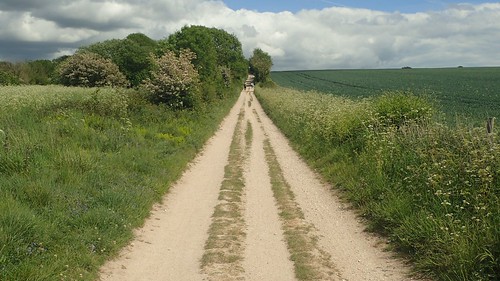
This is not the last time that I will mention the unforgiving nature of chalk beneath your feet for many dozes of miles. After two days, my feet were already feeling hot in places and small blisters had begun to develop. I also had a lump (possibly a ganglion) on the top of my right foot where it meets the ankle…
But in the photo above, you can see the distinct slat to one side of the track and that did make for exceptionally uncomfortable walking. Fortunately, I’d see nothing else quite like it over the coming days.

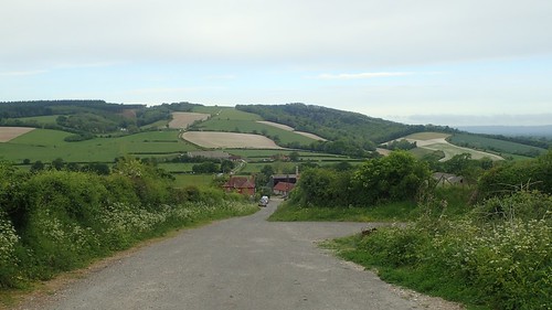
Another busy road crossing. This time, the A29 and I could see the village of Amberley beyond the end of my descent.

If someone would so desire, they’d be able to book accommodation at a nearby bunkhouse (which, oddly, doesn’t appear on the OS map). With the village stores nearby, there’s also the opportunity for weight-conscious backpackers to carry less for lunch and I’m sure I saw signs for a café further on.

Crossing the bridge, my mind was set on the idea of finding a spot beside the River Arun for lunch.

My moments of solitude were soon spoilt – along with that of the surrounding environment – when a group of four teenage cyclists arrived… Effing this, effing that and with MUSIC blaring out from one of their devices! Actually, I could debate the term ‘music’ as it wasn’t something I would ever listen to.

Another five minutes would pass before they would fight their way through the ‘effing’ kissing gate, having announced to the whole of West Sussex that they’d already missed their ‘effing’ train from Amberley station. I felt for the town of Lewes on that afternoon. Somewhat grateful I was not to follow in their lead!

After lunch, I found my first water tap of the day, alongside a track and ahead of the railway bridge. Without warning or notice, it appeared to have been turned off. I was quite disappointed to find this, although not running low on my own supply. Also reluctant to risk a detour to the other potential tap near the train station.

Having crossed the busy B2139, I followed a narrow bridleway alongside the road before beginning my next climb (it is true, when someone tells you that the South Downs Way route undulates).

One sign suggested I could be at my next campsite, pitching up in less than two-and-a-half hours. I liked the sound of this. If anything, I was feeling the effects of sleep deprivation. Aches and pains around my legs had begun to ease with the gradual lightening of my pack and I was keen to distance myself from the memory of those ‘effing’ kids.
Can you tell that I am not a parent?!
My next climb – which I anticipated would be my last of this day – led me up and away from Amberley and on towards Rackham Hill. While I wouldn’t exceed an altitude past even 200m above sea level, this was enough of a challenge for the rucksack on my shoulders, which must’ve still been in excess of 17kg by this point.

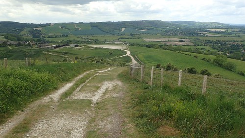
I remember this stretch of walking along the downs for the fact that it was constant, with the bare minimal of undulation and great views to both my left and my right. I believe I could see the rise and fall of the shadowy North Downs, away to my left. I’d like to consider the North Downs Way for another year but, at 153 miles in length, it’s a bit more than the five and six day treks I’m currently acclimatised to and my preference is to continue with more of these in the near future.

Along the South Downs Way, I did notice a lot of informative signs reminding dog owners to keep their pets on a lead when approaching livestock. These are more eye-catching, I believe, than the standard printed or carved text.

Crossing over Rackham Hill, my eyes were peeled to the right, eagerly seek out the next trig point…

But it was on private land, beyond a wire fence that was tall enough for me and my fifty litre pack. I didn’t pass a gate or stile of any sort and, well… This little lamb beat me to it.


It was along this stretch of the Way that I would encounter my first chance to ‘Meet the Farmer’. It looks as though you can scan the QR code with your smartphone and hear from the landowner himself. I imagine he has something more welcoming to say than ‘Geddoff moy laaaand…’.
But, with a limited mobile data allowance and a commitment to spending the minimal amount of time on my phone throughout this six-day trip, I decided to pass on the opportunity.
I can remember stopping in a grassy field a few hundred metres away from the next car park. It was close to 15:00 (a common afternoon break time) and my feet for calling for time out. Again, this chalk path was taking its toll on my already-blistered heels. Morning applications of zinc-oxide tape would help to reduce the friction and heat build-up but, since completing the trail, I’ve had to consider the possibility that the shoes I purchased last year are not best-suited to my feet.
This is a discussion I’ll cover in more detail another time. While I do love the space and width available around the toes, my Columbia shoes do not fit my narrowing rear foot [technical term] as snugly as other brands might… When I can also find the freedom to spread my toes is restricted, wearing a more acute-fitting shoe.

A few snacks, some liquid and shoes back on; I was ready to continue and would soon find myself following an almost-vacant stretch of the SDW, save for the very occasional passing cyclist. I mentioned earlier that people would’ve been returning to work on this Monday… But now, I realise it was still part of the Bank Holiday and I was surprised not to have seen more people rambling out and about.


No amount of complaining from within my shoes could suppress the pleasant feeling of having crossed the halfway point in my South Downs journey. I knew that it would happen at some point on Day Three. I’d neglected to pinpoint its exact location in advance. But to learn that you’re already closer to Eastbourne than Winchester, well, it’s a welcome discovery at any time of day!

Coming off the downs and on the final approach to Washington, I kept my eyes alert for an imminent water tap near Parkfield Farm.

Quite like the one six-miles west at Amberley, this tap had been turned off (although, I’ve since read that it’s been turned on again). At least there was a notice in place, giving the explanation of a leak.

While this generous service is often available and free to followers of the South Downs Way, someone, somewhere has to pay for the consumption of water and the maintenance. I’m surprised not to have seen a single donation box next to any of these taps. I’d have happily left £1 at a time to help with the upkeep.

Coming in to Washington, I would have to negotiate the safe passage across the busy A24 road. Further back up the hill is a signed opportunity to take a safer route along a road bridge to the north. While that would’ve meant bypassing the tap, I also decided that it sounded like the more cycle-friendly option.

I don’t sternly dislike cyclists as I have a number of friends who do travel considerately along on two wheels. I just don’t like having to constant look over my shoulder or step aside when I’m trying to make progress. Also, there were a number of occasions along this trail where I deliberately held a kissing gate open and waited for arriving cyclists to pass through without having to pause. All were very friendly, grateful and appreciative of my gestures.
Finding my way to Washington Caravan and Camping Park (aka. ‘Washcamp’) was easy. I even bypassed the pub where I think the two other walkers I’d met had decided to rest up in a B&B for the night.

Washcamp then, is a very secure and well-maintained site, catering for four-wheeled and tent-dwellers like myself. I was told I need not book in advance as they will always cater for people backpacking the Way. I was quite surprised to be charged £14 for my single night’s stay, in a non-electric pitch…
According to their website, I should only have paid £8. It’s possible I paid a premium for the fact that it was a Bank Holiday or because I was only staying the one night. Neither was explained to me and I didn’t have the courage to question that. But the cost of the showers was included, with hot water in a space where each ‘cubicle’ was the size of my bedroom at home!
I was given the freedom to pitch ‘anywhere’, with no set restrictions or numbered bays. I found the main camping field to be very exposed to the wind and it was where most of the kids were based. In the small paddocks near the hook-up points, I found myself alone, but for one camper van and awning… Although the resident kids would later decided this was the best place for their leisure time! At least they were less troublesome and younger than those I’d met at Cocking.
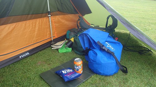
I treated myself to a can of Fanta and a bag of Kettle Chips from the vending machine… £1 each but it saved me having to hobble any distance on war-torn heels. You can also see the blue dry bag-pump that I used to carry my kit to and from the shower, leaving the larger rucksack in my vestibule. It was also adept at inflating my sleeping mat.


That pub was less than a ten-minute walk away and I could’ve taken the opportunity to carry another evening meal less. But I am a big fan of Firepot meals over all others and, if I’m going to carry something, I should eat it to justify the strain. Also, I’m generally more comfortable eating in pubs when I have company.

It was a really nice evening. No suggestion of rain, a flat a peaceful pitch and I felt good about my preparations for day four, having now crossed the halfway point in my journey.
