
Bank Holiday Monday 6th May 2019
It was time to begin the long journey home from mid-north Wales. A fantastic weekend of walking had left me with little energy to attempt another full day out with the prospect of conquering the Aran ridge.
But I wasn’t keen to press on with a four-hour drive to home and Normal Life. I’d thought about stopping off in the Cambrian Mountains, maybe even the Brecon Beacons or Shropshire… I was invited by my friends, Dave and Susanna, to join them on a fairly-local walk they’d discovered online the night before.

We drove for almost forty-minutes, heading south-west from Llanuwchllyn, our car boots rammed full with our camping kit. Our destination was a village called Abergynolwyn, in the heart of the Dysynni Valley and its slate-mining heritage.

Leaving the A487, we immediately passed the bustling car park to the south-east of Cadair Idris. That same space we’d set off from in May 2017. It was so busy, cars were aligning themselves along grass verges of the busy A-road. Following my SatNav, I was completely unaware of where we’d be heading and what we might pass by.

Another ten minutes on and we arrived in this almost-ghost town of a village, parked our cars safely and began the walk. We were following a walk from the AA’s online series – which seems to have recently vanished. But fear not! If you’d like to see the route for yourself, it’s also been recorded at Mud and Routes.
There was a lot of hesitation between the three of us in the very beginning of this walk.
‘Were we in the right car park?’
‘Is that lane the one we’re supposed to walk along?’
I’ve had my own run-ins with AA walk descriptions and it was relief to find I’m not the only one who struggles with them.

Crossing the river to the north, we soon took a footpath on the right and found ourselves heading up and away from the village.

We then followed the next road to the north-east for almost 2km, past Cedris Farm, as far as Pont Cedris, where it meets the B-road and to begin a punishing climb up Coed Cedris.

To my mind, ‘Cedris’ is a near-perfect abbreviation of Cadair Idris…

At the top of this field, we continued on and up through the grove with bluebells surrounding our ankles.

We would turn left at a junction with a track and follow this towards the Nant yr Eira running down the next valley. Up to our right now was the mighty Foel Ddu. There’s no charted track leading to its 448m summit but I’ll bet some having begun that journey from here.

Climbing a ladder stile, we found our first marker for the mysterious ‘Mary Jones’. We’d seen this name on a signpost (for Mary Jones World…) near Bala Lake, the day before.
According to what I’ve read since… Mary Jones was a girl who walked barefoot across Wales to share the bible… If my memory is at all accurate.

An impressive valley awaits, with bluebells covering the hillside to our left.
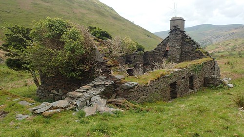
These ruins of a cottage or farmhouse sit a short distance to the right of the main path. I’ve no idea of its history but a couple of stone slabs (probably slate) provided access over the boggy stream.


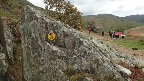
Nearing the end of our descent, we passed a group of DofE-type youths and another marker for the Mary Jones Walk.

Close to the sound of shallow waterfalls, we stopped for lunch in a field of sheep’s poo but with this view ahead.


This walk led us in to Llanfihangel-y-Pennant…

Where we passed the Mary Jones Chapel.
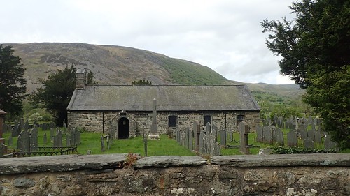

Looking north-east from here, it is said that one can make out the ‘bowl’ of Cadair Idris.

Walking south-west down the road, we would soon arrive at our next stopping point, where even a small car park is available (without a charge).

I’d never heard of Castell y Bere and I didn’t know of what to expect. I hadn’t even spied it on a map of the area.


…It goes without saying that we were all impressed with the discovery.


I’d seen the signs, in both English and Welsh, advising visitors not to climb or walk along the walls. But these rules apparently didn’t apply to one native-tongued tourist, who led her child up and along most of the remaining walls.
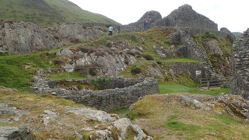
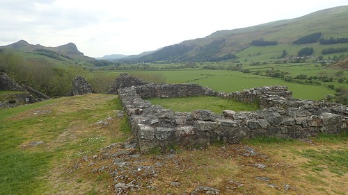


I don’t know how much time we spent exploring this site of Cadw. It could’ve been forty-minutes; might’ve been one hour. But it was certainly time very well spent.


A possible glimpse of Cadair Idris’ Penygadair summit… Possibly not.

Continuing with our walk, we took a footpath from the roadside that led us along past the farm buildings of Caerberllan, to join another road, up to a junction with a phone box (Teleffon).
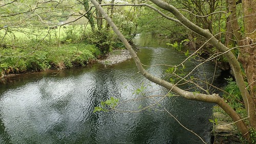
From Rhiwlas, we follow a riverside path back in the direction of Abergynolwyn.


Our path soon began to climb up, gently and away from the water’s edge. I believe the summit above is Foel Cae’rberllan.


Near the height of our elevated gain, we found these hooks embedded in the stone and not to mention the square areas house out of the same rock. Remnants of a bygone industry, perhaps?

Before long, we’d find our way back to the start in Abergynolwyn and remark on the frequent use of slate across most buildings.


A great few hours spent exploring an almost-unknown pocket of Snowdonia and its many valleys. No mountains climbed but a very good outing. Ahead of me now was the four-hour drive home.
