Thursday 15th September 2022
In another two-part write up, I’ll share my experience of the one walk I was most looking forward to in this week away – climbing Helvellyn via. the scramble of Striding Edge.
My morning began in the town of Glenridding, to the east of the mountains.

Another Lake District walk; another morning of paying £8 to park for the day! Shopping around, you can pay half as much but then you’re further out from the centre of the village.
From Glenridding Bridge at the side of the main road, I could look along Glenridding Beck to the vista of mountains (and surely, including Helvellyn) beyond. My walk would begin along a bridleway, which follows the left-hand-side (southern) of the river.

Having just spent my first night inside a tent at a small campsite to the east of Windermere, I’d then enjoyed a dramatic drive down the steep descent from Kirkstone Pass. I’ve heard many tales of Hardknott Pass but I’ll save that experience for another year!

I’d set off from an elevation of below 200m above sea level and knowing that Helvellyn – one of the tallest mountains in Cumbria – was more than 700m higher. This was going to be an exerting first half to the walk!

I turned south along the footpath at Westside. Then west across Miresbeck. On to the Open Access Land towards Little Cove and keeping the river, Mires Beck, on my right as the gradient continued to rise.

In respect to the landscape and those who look after this National Park, I followed the meandering detour away from the dry-stone wall and path erosion near Birkhouse Moor.
I’d heard of such footpath closures and diversions before. Perhaps they’re more frequent around Scafell Pike. I’d seen them around Ingleborough in the Yorkshire Dales but this was the first I’d encountered up in the Lakes.

Another busy day for walkers and I was pleased to see that all of the others were sticking to the redirected route.

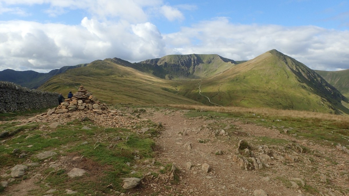
Many steps later and my calves were delighted to have reached the end of that torturous climb. Ahead I could see the summit of Helvellyn in the centre and with Striding Edge to the left. To the right is the pointed Catstye Cam – perhaps I’ll visit that on another year.

I’d first though that Caststye Cam was Helvellyn. But looking closer at the centre of this perspective, you can see the cairn that marks the highest point.

After two hours of hiking, I stopped for a short break just past a point marked as Hole-in-the-Wall. It’s not a pub and, funnily enough, there’s a gap to pass through the drystone wall!
Yes, it had taken me two hours to reach this point and I hadn’t quite met Striding Edge and knowing that Helvellyn stood beyond. When you set out to “do” something like Striding Edge, it’s worth remembering that you won’t be able to step on to it from the car park. In the same way that the start of Crib Goch is a fair trek and scramble away from the Pen-y-Pass car park of Snowdon.

Helvellyn was looking close. I was almost there and could see human figures gathered on the top.

Refuelled with snacks and peppermint tea, I strode on to the Edge. Having allowed a few others to walk on ahead of me and on or two to have come down from the opposite direction.
Navigation can be as simple as keeping to the left of Red Tarn to follow Striding Edge. Or bearing right to head up Swirral Edge – perhaps I’ll also tick that one off next time (it’s regarded as being easier).
Safety may be another matter… An increasing number of people have died having fallen from Striding Edge. I was very fortunate with the relatively dry and still conditions for my walk. But I would never attempt an exposed ridge-walk like this in strong wind, wet or icy conditions.

I did find that Striding Edge is less intimidating than Crib Goch. I wasn’t as terrified at the sight of the drop on either side. There are paths in parts where you can walk beneath the knife-edge but they won’t last the full duration. Some scrambling may be required. You don’t have to tip-toe along the very point of the Edge.
Downclimbing (not bum-sliding) is advised for one section towards the end. It’s known as The Bad Step and is where some of the most recent fatalities have occurred.

I didn’t see anyone else struggling to the point or panic or wanting to turn back. Some were naturally slower and more cautious than others. It is never about winning a race or setting a new pace. I enjoyed this experience, even in moments where I didn’t feel immediately confident of being able to get down.

Looking back, it’s a staggering feature of the landscape. Again, I was incredibly fortunate to have been here on such a fine day. Only three days after the weather wrote of my plans to reach Scafell Pike.


I passed this memorial towards the end of the Edge and there’s a cross to find, further back. I couldn’t clearly read either and that walking pole… Not mine. An accident that may perhaps benefit another weary walker.

One final push towards the trig pillar and suddenly, this mountain top looked to be as tame as Pen y Fan in the Brecon Beacons.

As I reached the cairn where others were gathered, I looked across to my left and saw a familiar figure. Red jacket, blonde hair and sunglasses… She looked a lot like someone I know from Brunel Walking Group in Bristol…
She waved at me. It WAS Harriet! She was up here for a few days with her partner. We were both perplexed to have bumped in to each other in such a place and a good five hours’ drive from our homes! What were the chances, really?!

One could spend the day up here, admiring the views all around.


Most walkers seem more intent with reaching the cairn than the trig pillar. While it wasn’t particularly busy here, I slipped away towards the south-western slopes and sat down for lunch.
In my next post, I’ll continue with this circular walk, heading towards St. Sunday Crag. I’ll also include the link to and map of my full route.
Would I recommend Striding Edge?
Absolutely! One of the best scrambles I’ve done.
But as I said earlier, I’d only recommend doing it in good weather and with all of the right precautions (decent boots and layers, food, water, letting someone know where you’re going, if you are going solo).
Thanks for reading.

Another good read Olly and sensible advice for others that wish to follow in your footsteps. 👍🙂
LikeLike
Looks like a rewarding hike
LikeLiked by 1 person